Tho’ it ain’t a life o’ pleasure, An’ there’s little time for leisure, It’s contentin’, in a measure, is the game of growin’ Wheat.
C. J. Dennis ‘Wheat’ 1918
Introduction
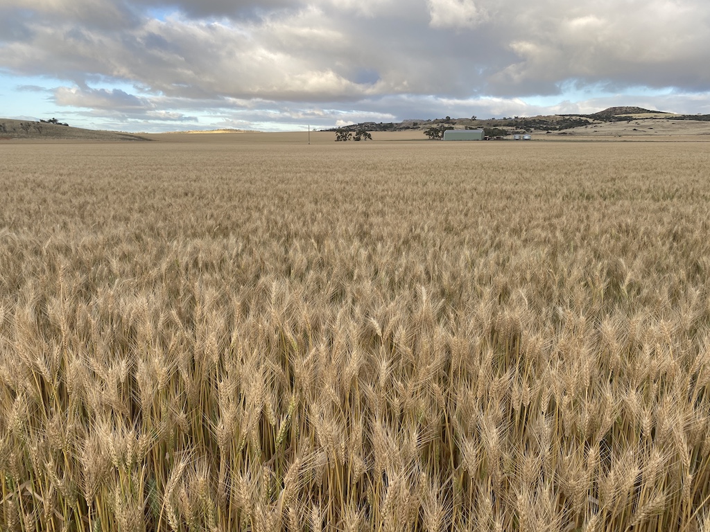
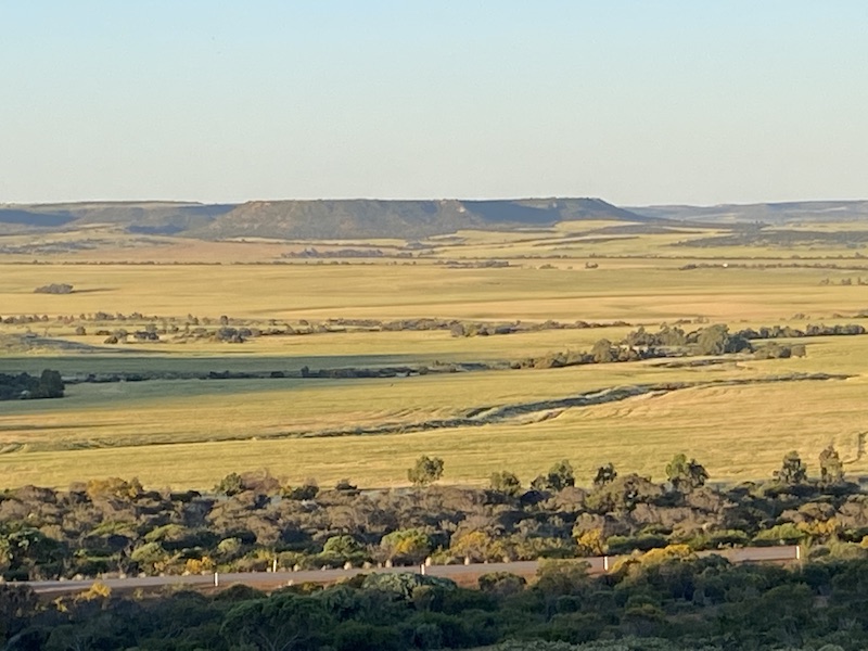
The Wheatbelt region in southern Western Australia extends across a large area as a crescent and is one of the few major agricultural regions in the world viewed from space. It stretches from the west coast near Kalbarri in the north in a south-easterly direction to the south coast east of Esperance. The eastern extent is limited roughly to the 300 mm rainfall isohyet.
The region is named for wheat, the main agricultural product in its early development. Today, the area is a much more diverse agricultural producer. While wheat is still the dominant commodity, based on the gross value of agricultural production at $2.1 billion, barley is valued at $1.3 billion, and wool is at $801 million. The Wheatbelt is the most significant farming region in the state, containing 55 per cent of all farm businesses.
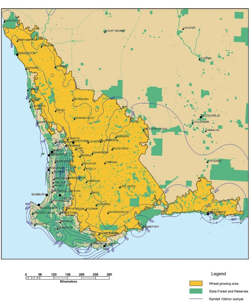
Wheat production accounts for 70 per cent of Western Australian cereal production, with about seven million tonnes generated annually in a rain-fed system across four million hectares of land. Western Australia generates about 50 per cent of Australia’s total annual wheat production.
Non-cereal crops are dominated by canola, which comprises nearly all oilseed production in Western Australia. More than 40 per cent of the total canola grown in Australia comes from the Wheatbelt. The seed produced has consistently high oil content, making it appealing to oilseed crushers for its greater yield.
The Western Australian wheat sector is considered a world leader in producing quality, safe and clean wheat. This is mainly due to a dry harvesting environment, resulting in a low risk of weather-damaged grain and low moisture content.
More than 80 per cent of the wheat is exported – predominantly to Asia and the Middle East. Indonesia is Australia’s largest wheat export market accounting for around 2.3 million tonnes each year. White-grained varieties generates high flour milling yield and a bright white flour, suitable for use in a wide range of products, including all types of Asian noodles, such as udon, ramen and instant; Asian, Western and Middle Eastern style breads; Asian steamed products; and biscuits, cakes and pastries.
The area sown to wheat in the Wheatbelt over the past 20 years has remained relatively stable at about four million hectares. But over this same period, production has more than trebled from two million tonnes to seven million tonnes – a productivity growth rate higher than the world average. Plant breeding advances combined with wheat agronomy research and development have led to significant increases in wheat yields per hectare over the past 100 years. However, variable seasonal rainfall means wheat yields vary widely from season to season. The 2021 harvest was a once-in-a-generation event with many growers enjoying the trinity of good yields, quality and prices after a very favourable wet winter. A record 21 million tonnes of wheat, canola, and other cereals valued at $8 billion were harvested, all from an area that nearly resembles a desert in its natural form.
The development of the Wheatbelt region
It first started as an agricultural dream. The colony on the Swan River formed the basis for a series of closely settled farms owned by hardworking farming families living in harmony with the land and providing grain for the hungry populace. The physical constraints were underappreciated, and the dream was far from a reality in the early days. There were almost no rivers, so water during summer was rare; the climate provided four to five months of no rain; desert winds blew across the landscape; and the soils were ancient and not very fertile. Combined with the tenacity of the native vegetation to withstand clearing, it underlies a remarkable story of an area that today is so productive. This has been achieved by the ready adoption of new methods to improve yields, despite a rapidly declining population.
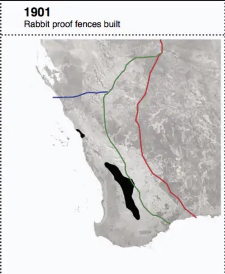
The Wheatbelt story was created over two 30-year periods – 1900-30 and 1945-75 – where land the size of Great Britain was cleared of its native vegetation. Its genesis began during the gold rush in the 1890s, when the colony’s population trebled to 138,000. With the discovery of gold waning, the government wanted to keep the new settlers to “transform the empty wilderness’’ into wheat farms to solve its unemployment problem. So, they introduced the Homesteads Act 1893 to survey land and established the Agricultural Bank to provide finance. This was particularly the case post-WWI for Returned Servicemen under a scheme administered by the Agricultural Bank.
Of course, the land was far from a wilderness, having hosted Aboriginal people for millennia who ate from the landscape through the use of fire to sustain themselves.
But the development of a new colony took precedence to favour European farming at their expense. The major drought in 1914-16 nearly caused a massive abandonment of these new farms. The government was concerned about losses to state assets, particularly its enormous investment in rail infrastructure. They set up the Industries Assistance Board, which supported the wheat industry through indifferent seasons until conditions improved after WWI. According to its potential, the land was categorised as first, second or third class. By 1920, all the first-class land was alienated. Much of the remaining land was marginal on lighter sandy soils, far away from the railway and with questionable rainfall.
Settlers were set up on bush blocks and given financial aid to start from scratch. Not many succeeded. The Great Depression, droughts, plagues of rabbits and emus, and a crash in the world wheat price halted any further clearing work and development. Western Australia was still a net importer of wheat, but this changed in the next expansive clearing period after WWII.
The stark and uniform Wheatbelt landscape has inspired some classic Australian literary works. Probably the most famous is Albert Facey’s autobiography, A Fortunate Life. Facey worked for the Water Board, clearing bores and building reservoirs and dams in the Wheatfield before WWI and later lived at Wickepin after the war and through the Depression.

Even though he records the hardship and poverty of small-time selection in the Wheatbelt, he remembers with pride the annual burning of debris and the cutting of the wheat crop.
Despite the setbacks, the early settlers chose the heavy clays and loam soil types, shunning the lighter soils. This was because most first crops were sown without fertiliser, and the lighter soil would not produce anything worthwhile without fertiliser. The former soils also carried gimlet (Eucalyptus salubris) and salmon gum (Eucalyptus salmonophloia) which supported little understorey.
Settlers ringbarked the larger trees, and wattles were used to fire the dead trees when they had dried sufficiently. Ringbarking York gums (Eucalyptus loxophleba) was less successful because it suckered new growth at the base of the dead tree. Areas of jam tree (Acacia acuminata) were prized as they made excellent fence posts, lasting up to 50 years. From around 70,000 acres in 1890, the area under crop in the Wheatbelt exploded to almost five million aces by 1930.
After WWII, a different approach was adopted for the returning servicemen. The Soldier’s War Service Board had the first option on any Wheatbelt farm up for sale. It meant servicemen were set up on established farms with low interest, long term loans. Over 1,100 farms were established through this assistance. Western Australia was one of the few parts of the developed world to undertake massive land clearing operations. Government research stations were established employing agricultural scientists. They experimented with applications of copper and zinc on sandy areas.
Consequently, nearly all these settlements were successful with government assistance. It certainly was a boom period for the development of the Wheatbelt. From 1958, the government offered land for sale under conditional purchase arrangements at a rate of more than a million acres a year. Many of the new farmers who flocked to the cheapest land in Australia had never farmed before.
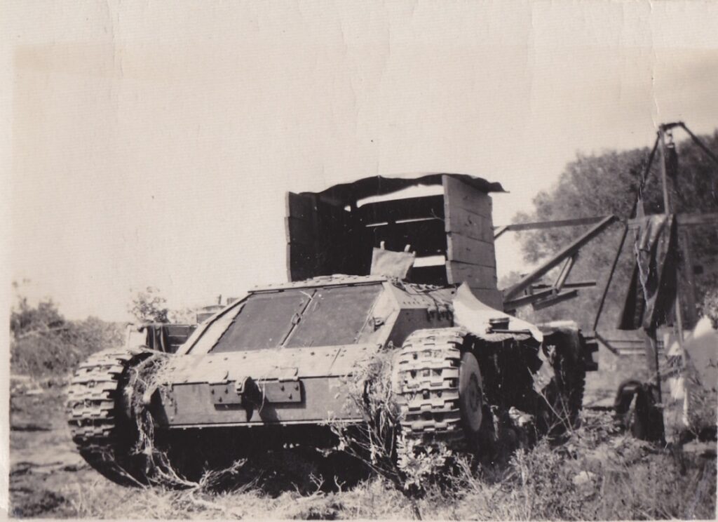
Gradually the clearing method changed from the basic ringbarking to a cylindrical steel roller, commonly known as a “scrub roller” pulled by bullocks. In the 1930s, small crawler tractors were introduced to pull the scrub rollers. After WWII, the new clearing focused more on the lighter soils that carried scrub and mallee. A more robust clearing system was required. Two large crawler bulldozers pulling hundreds of feet of heavy anchor chain were introduced. Most of the north-east and eastern Wheatbelt were cleared using this method. When there was a large shortage of bulldozers to do the clearing, farmers took advantage of the glut of armoured vehicles in the post-war United Kingdom. Valentine tanks were imported with a few modifications.
Whatever the method, the post-clearing fire was a big event. In the pre-machine days, men had shovels and rakes, wet bags and a leather flap on a stout handle to control any outbreak of escaping fire. They would wait for a good stiff night wind to keep the stumps alight and they saved days of labour carrying, by hand, wood to stack up around any stumps not burned to or below ground level. Or, after dinner on the night of the burn, and for the next few weeks, they carried coals by shovel from big ember heaps and placed them on the up-wind side of the stumps that had not caught alight.
The farmers with a plough and horse team often ploughed the land in late winter following the burn. Many roots and stumps were exposed and subsequently burnt on other remaining solid stumps. This made the paddock cleaner it more viable for a mower to cut the crop. The crop was hand broadcast on foot, and then a log was dragged over the area by a horse to level and cover the seed. Farmers with a disc drill would roll over obstacles and drill the wheat evenly in seven-inch rows.
However, the clearing of sand-surfaced soil exposed them to wind erosion and soil drifting. Some form of control was introduced through regulations. Two soil conservation districts were declared in the north-east and eastern districts where clearing required a permit. Landholders were required to provide three months’ notice of their intention to clear their land. A soil conservation officer inspected the property to introduce measures to minimise the risk of soil drift to roads and fences. The regulations were less about restricting clearing and more about dealing with a difficult soil erosion problem. They failed to address other causes of erosion, such as overgrazing and over-cultivation.
Technological advances and improvements
Early wheat varieties were much taller than today’s plants and often suffered yield loss through disease rust. They were bred or selected for height because not only did the wheat plant provide grain at harvest, the stem from the cutting of the crop for hay was used to make chaff. Chaff was an essential part of the farm cycle to feed horses and supplement the feed for milking cows. The taller the wheat crop grew, the greater the length of straw for chaffing. Also, on the roughly cleared ground, the taller crops were above the roots and suckers by a greater margin, making damage to the harvester less likely. However, Western Australia’s wheat growers struggled from the outset as they used these longer varieties that were not bred specifically for the shorter growing season.
When the need for hay quality wheat declined, and science found that less growth on the plant left more resources for the grain, shorter, dwarf varieties were introduced. In the early 1940s, the average yield broke through the one tonne per hectare barrier. This was due to new varieties better suited to the Australian environment and improved farming practices. In the 1950s, the average yield generally remained above the one tonne per hectare level, and one and a half tonnes per hectare was achieved for the first time in 1979. This boost in yield was needed as significant fluctuations in the price of wheat have been caused by wars, the Depression, unpredictable climate and volatile market forces over the last century. However, the long-term trend for price levels is downwards, driven mainly by supply and demand factors.
If the first crops were small, they were cut with a hand sickle and shifted by cart to a stack to be later threshed and cleaned by a mobile steam-driven thresher. The first mechanical harvesters were purely strippers, a set of beaters running under a cover to hit the ears of the wheat as they fed through the comb and stripped the heads from the stalk and flicked the material rearwards into a holding tank. They were pushed by two horses rather than pulled. The beater was belt-driven. The grain, chaff, straw and unthrashed heads were emptied and put through a winnower for final cleaning.
November to January was always the culmination of the farmers’ hard toil and investment. In the early days, when the crop matured, the crop was cut and bound into sheaves with a horse-drawn binder. The sheaves were stood heads up, leaning together in stooks of ten to twelve sheaves, waiting for the threshing machine. The reaper/stripper machines, such as the Ridley and the Peacock, consisted of a fingered comb four to seven feet in width with rotating beaters stripping the heads from the straw and tossing the chaff, grain and litter into a tank behind the comb. Finally, the grain was cleaned and ready for bagging.
The original dream of bountiful fields dotted with homesteads and satellite towns was never going to succeed in the low-nutrient landscape and so far away from its intended markets. Only large-scale industrialised farming could make the Wheatbelt a viable proposition. It started with the steam engines on the early harvesters and progressed to what we now call the combine.
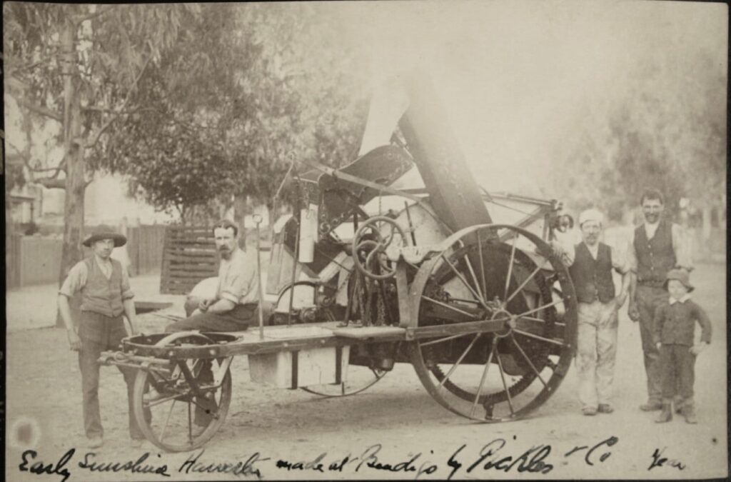
Industrious farmer-inventors continued to streamline the harvesting process. In Australia, John Ridley made a successful stripper harvester that simply stripped the heads off the wheat stalks. Another Australian inventor, 20-year-old Hugh Victor McKay, refined the process and created the first commercial combine harvester called the Sunshine Header Harvester in 1885. The machine was revolutionary as it stripped the standing grain heads, threshed the grain, and cleaned it in one operation.
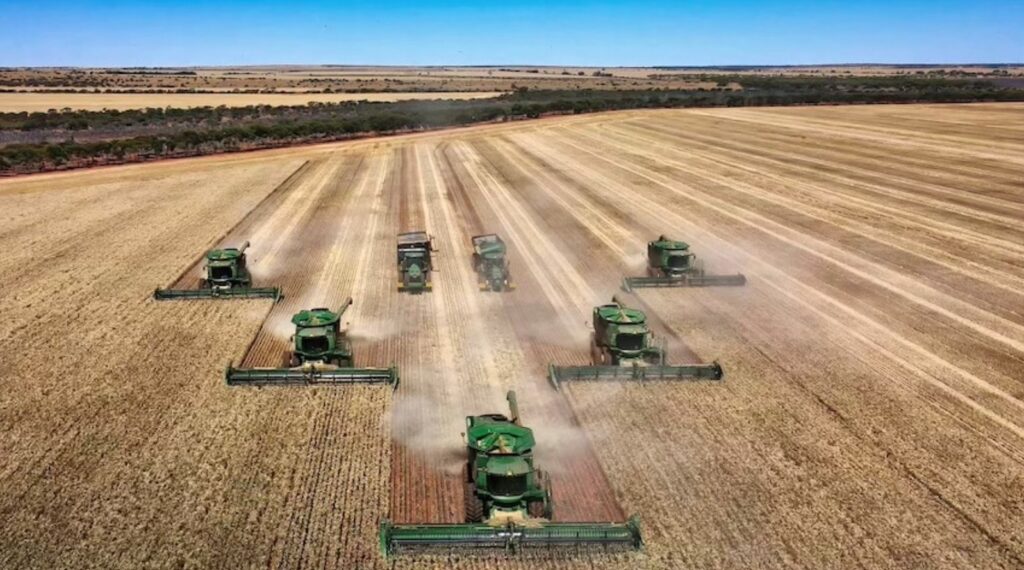
Around 1950, many farmers moved to part bulk handling, still bagging the wheat off the header. However, the introduction of tractors with power take-off drives in the 1950s, combined with the new headers, revolutionised harvesting and allowed the bulk handling of grain. It was necessary as handling and transport costs were crippling wheat farmers. The header cuts heads of grain from the stalk using a knife mechanism, and an auger channelled the grain to a threshing mechanism consisting of a rotating drum. Trailer bins replaced boxes on the headers, and then grain was augered from the header direct into bins of trucks. It allowed the harvester to operate continuously without stopping to unload. A further development was the tractor-pulled chaser bins that drive up to the harvester as it performs. These bins have a capacity of 15 to 40 tonnes.
A diesel-powered bucket elevator to move wheat from storage bins into railway trucks was first trialled in the early 1940s. As a result, farmers saved up to two pence per bushel. Considering that there are around 37 bushels in one tonne of wheat, that was a significant saving. The trial’s success highlighted the advantage of cooperative bulk handling and led to the formation of a new company – Co-operative Bulk Handling Ltd (CBH). They administered and expanded the bulk handling of grain by organising storage, marketing and processing of grain. It remains a farmer’s cooperative with more than one billion dollars of net assets. Along the way, the labour force was halved, further adding to reduced costs and allowing farmers to survive when wheat prices stalled.
In 1955, all grain port facilities were handed over to CBH control and management. In 1961, a standard gauge railway was finally introduced throughout the Wheatbelt and to the coast allowing the expansion of the CBH storage system. Sites were rationalised as receival systems became more efficient, seeing many silos dismantled. These days the delivery of grain to bulk handling depots is carried out by road trains capable of transporting 65 tonnes of grain.
The highly erodible sandy soils characterise a considerable portion of the Wheatbelt, and the conventional cropping systems led to the surface exposure of soils for lengthy periods. As a result, excessive tilling destroyed the soil structure and reduced soil fertility.
A team of horses pulled harrows to break up clods and help create a finer seedbed. In addition, they were a valuable tool to kill surface weeds that germinated immediately after sowing.
With the advent of hydraulics on tractors, heavy harrows mounted in frames were used to heap weeds and surplus trash into rows for later burning. This reduced the build-up of rubbish in the combine seeder tynes. The harrow also created a fine surface layer called a “dust mulch,” reducing moisture loss. Unfortunately, the result of all this tilling was severe erosion.
In the 1950s, the introduction of bipyridyl herbicides that killed seedling weeds was seen as an opportunity to replace mechanical tillage in seedbed preparation. Seeding began shortly after the first adequate rain of the season, but seedling weeds would emerge. The release of the glyphosate herbicide in the mid-1970s allowed weed control and reduced till operations before sowing. Rather than till the entire field, current sowing operations produce a fine tilth only in the immediate area occupied by the wheat seed, significantly reducing damage to the soil structure. This necessitated new technologies such as single-pass seeding into crop stubble to reduce compaction, soil disturbance and moisture retention.
Improving water use efficiency has been the latest key innovation to increasing crop production in dryland agriculture. Farmers now use a range of spatial data, yield maps, and GPS to plant as close as three centimetres from last year’s row to capture any moisture that has been retained. They also only fertilise productive sections of the paddock to benefit the crop.
Today, there is a new breed of farmer. The development of technology helped the wheat farmers move towards low cost, low labour, and extensive production systems. They use immense horsepower machines and a lot of chemicals in sparsely populated areas. They have had to find a way to grow a crop and “squeeze every ounce from very little rain”. Introducing a ley system of alternating between grains and pastures is a cheap and effective way of restoring soil structure and fertility to worn out wheatlands and raising the yields of grain harvests, the number of livestock, and the weight of fleeces.
The salinity problem
The land taken up in the Wheatbelt was under the Conditional Purchase title, with conditions such as a minimum amount to be cleared in a given time and boundary fencing. Failure to meet the conditions of purchase meant that the property would be forfeited to the Crown and made available for selection by another person. Unfortunately, the social and economic demands for clearing the land for the generation of wealth to the state led to some significant issues, the chief one being salination.
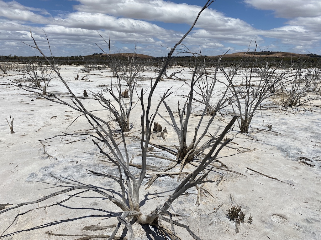
The large scale clearing of native perennial vegetation and replacement with shallow-rooted annual introduced species has resulted in changes to the hydrological processes. Salt lakes and pans were a part of the landscape before settlement. This is mainly due to salt transfer via rain from the oceans over thousands of years, which has led to immense storage of salt in the soil profiles.
However, European farming practices exacerbated the salinity problem. The removal of native vegetation led to increased evaporation and a rise in water tables. The water rose to the surface, loaded with salt. The wind blew the water away and left the salt behind. Sheep compounded the problem by eating the grass, or the grass simply died. After the rain, the brine discharged into watercourses and led to the salination of fresh-water lakes, killing trees. The irony was that underground water was shallower and less saline under the lighter soils, usually in the form of water soaks.
When perennial trees vegetated the landscape, the hydrological balance was largely maintained, and sub-surface water levels were safely below ground level. The valley floors and large flats of the Wheatbelt are the better soils and were cleared first. However, with the run-off areas being later cleared, the rains that fell on those areas were no longer held and used there. Instead, the rainwater ran or percolated to the lower regions, where the salty water eventually rose.
While it is easy and convenient for city folk to blame the environmental problems in the Wheatbelt solely on the farmer, they fail to acknowledge that governments, with the support of society, encouraged clearing to raise state revenue. The Condition of Purchase system demanded a clearing program that, in hindsight, was unwise.
As farmers began to lose productivity due to the growing salinity problem, they approached the bureaucrats at the Department of Agriculture for advice. Unfortunately, they initially encouraged farmers to buy more land as that was easier and cheaper to deal with the problem. Obviously, under this sort of encouragement, farmers made errors in areas they cleared.
The worst period for the wheat farmers started around 1969 when drought and a glut of wheat on international markets led to quotas. It was also at this time that the land turned salty. A period of consolidation followed in which farmers bought up many marginal neighbours. However, government encouragement and support were still there. In 1980, the government announced the release of three million hectares for agriculture in the far south coast near Ravensthorpe.
Marketing issues
In the past, Commonwealth and state governments provided the wheat industry with financial assistance in guaranteed minimum prices to growers and investment in storage and handling and regulatory control.
In 1915 the Commonwealth Government set up a wheat pooling scheme to assist wheat growers and ensure appropriate management of this vital foodstuff during World War I. It was administered by an Australian Wheat Board (AWB), comprising the Prime Minister and a Minister from each wheat-growing state. Under the scheme, returns from each season’s wheat crop were pooled (over time and across markets) and shared fairly among all growers for the duration of WWI.
After the first AWB ceased operations in 1921, regional wheat pools continued, often managed by farmer cooperatives.
At the beginning of WWII, the AWB was re-established as a statutory authority under National Security (Wheat Acquisition) Regulations to handle all matters connected with wheat disposal. Following the war, legislation was passed to establish the peacetime AWB in 1948 as a single desk to shelter growers from volatile wheat prices. The purpose of the AWB was to ensure that the wheat industry operated in an environment of price stability and orderly marketing and was responsible for the sale of virtually all wheat produced in Australia.
In 1969, restrictions were placed on the quantities of wheat that could be delivered to the AWB in the form of wheat quotas. It attempted to reduce the potential build-up of excessive carryover stocks after the record 1968–69 Australian wheat harvest coincided with the build-up of world wheat stocks.
In 1979, new legislation gave the AWB power to issue permits to growers, allowing them to deliver wheat directly to a domestic customer rather than into the bulk handling system.
In 1984, the domestic feed market for wheat was effectively deregulated, and growers could sell, under a permit system, to anyone they chose. This was the first step in the deregulation of the Australian domestic wheat market and was designed to benefit the industry by injecting greater flexibility and competition.
By 1989, the domestic wheat market was deregulated entirely. At the same time, the Commonwealth government established the Wheat Industry Fund through a compulsory levy on wheat sales to create a sufficient capital base for the privatisation of the Australian Wheat Board.
In 1999, the AWB ceased operation as a government-controlled statutory authority. Instead, it became AWB Limited, a grower-owned and controlled corporation that effectively was the monopoly wheat exporter from Australia, or what was commonly referred to as the “single desk” where the returns from growers were pooled together nationally and the prices averaged by AWB. Farmers liked the system as it allowed AWB to get the most out of overseas markets and enabled effective promotion and sale of Australian wheat overseas.
A low point was the controversy that hit the AWB through the Cole Inquiry, where AWB was found, in the mid-2000s, to have paid kickbacks to the Iraqi regime in exchange for lucrative wheat contracts. The United Nations oil-for-food scandal effectively destroyed Australia’s monopoly wheat export system known as the single desk.
While Australia produces only about three per cent of the world’s wheat output, it exports to more than 40 countries. Australia’s total wheat exports represent around 15 per cent of the world wheat trade annually. With the loss of the single desk, more than 30 registered exporters for bulk sales entered the fray.
Landcare
Western Australia was one of the founding states of the nationwide Landcare movement. The growth of Landcare in the state was astounding. More than 60 per cent of farmers and 90 per cent of pastoralists were involved in the community action programs directed at reversing land degradation and achieving long-term sustainable land use.
For the Wheatbelt, the central issue was salinity. In 1996, the Western Australian Government launched a Salinity Action Plan to address dryland salinity in the state for over 30 years. The major focus of the plan was government, industry, land managers and the community working together to combat salinity. Sadly, it was more of a political exercise, and little guidance was provided to continue the program.
In the mid-1990s, Natural Resource Management organisations were set up. At the same time, there was a significant change in attitude within the rural population to salinity and sustainability issues with stock excluded from large areas of degraded valleys.
In the early 2000s, there were fundamental changes in the structure and organisation of Landcare in Western Australia, which was driven by a reduction in bureaucrats assigned to support Landcare programs, less funding available for local facilitators and an ongoing population decline in the Wheatbelt region.
Surprisingly, there are many remnants of native woodlands and forests set aside by George Brockway, a forester who had the foresight to protect these areas. But sadly, they just sit there unmanaged and in a terrible ecological condition due to benign neglect and ongoing wildfires.
Concluding remarks
Whatever your viewpoint on the clearing and salinity in the Western Australian Wheatbelt, your best to experience the area first-hand to see the patchwork of golden fields across the vast landscape, learn about the pioneering history, and visit the small towns that retain their historic character. Today, the very low population density and lack of bustling townships belie a large-scale industrialised farming system that flourishes with very little rain and greatly contributes to world nutrition.
As they faced economic pressures, erosion and salinity land degradation issues, farmers managed to adapt their practices to conserve the soil while improving production. The challenges remain, however, as farmers continuously face pressures to improve economies of scale to remain profitable and operate sustainably on the land.
What future do they have, and can they continue to adapt?
Well researched Robert.
However, one of the most important commercial transfers of knowledge from fundamental science to operational practice on a massive scale occurred with dry land wheat growing and needs including in your historical piece. Professor Graham Farquhar ANU and Dr Richard Richards CSIRO were awarded the 2014 Rank Prize for crop husbandry and crop production for pioneering research which led to the development of new wheat varieties that flourish in dry conditions.
Water supply remains the greatest limitation for grain production and agriculture in WA, Australia and world-wide. Farquhar first found that heavy carbon uptake was a key pointer to water use efficiency and together they succeeded in breeding new commercial varieties that grew 10 per cent more, but with the same amount of water. That meant a 10 per cent increase in yield in the driest conditions, sometimes more. The results are portable to other crops and countries.
Another great story Rob and close to my heart as I spent a fair bit of time in WA in my younger years. My wife and I lived in her home town of Kalgoorlie when our oldest was born and we frequently went down to Esperance for long weekends and other holidays. The Wheatbelt started around Salmon Gums at the lower limit of the rainfall zone and it looked like a tough way to make a living. The opening of land in the Esperance region commenced around 1960 and was one of the last big land releases in Australian agriculture. Some wealthy US families were involved in the development (Rockerfellers and Linkletters) and it’s a story in its own right
We all need to be careful not to overstate Australia’s contribution to world wheat production. Even though it was years ago, I never forget being asked by an agriculturist “who do you think produces the most wheat annually – Australia or France”. I immediately said Australia. Who thinks of France and conjures up images of rolling wheat fields and huge storage silos? Not me, anyway. I was wrong of course! It is France and by a long shot. I’ve just looked up a recent figure – in 2020 France produced twice as much wheat as Australia (30 M tonnes versus 15 M respectively). Our total production area is very large but, because of the soils and dryness, the average yield per hectare is very low by international standards. So there you go.
Thanks Ian. Next month’s forestry blog is a story on converting the sand plains behind Esperance for farming.
That will wrap up my series of land management stories I observed from my seven months of travelling around WA.
Look forward to your Esperance story.
I think the property known as Linkletters (on the south side of the Cape le Grand Road) ended up in Elders’ MIS blue gum scheme. FEA inherited it. They were chasing the slither of Esperance land in the 600mm and greater isohyet.
I saw it when it was about 5 years old and it was an absolute disaster by Tasmanian standards. I had been visiting plantations in the Albany area on the same trip and, even though it should have been pretty obvious to me, I learnt from my host that average rainfall was the first criterion looked at when the MIS companies were looking at properties to buy or lease. As someone operating in NW Tasmania and in particular Surrey Hills, rainfall wasn’t on the list of variables to consider. It was always expressed in that very technical term – “enough” – but replaced with frost and cold risk!
Another very interesting account of Australian land management and how it evolved from the start. Great pioneers those early settlers.
Thankyou Robert.