At 9.00 pm that night, it came bucketing down nonstop. It was so loud that it was hard to hear anything. By 11.00 pm, I thought it was pointless to go to bed and looked outside to check this downpour, with thunder rumbling and lightning flashing around us.
A resident describing conditions in Gympie on Friday night, 25 February 2022.
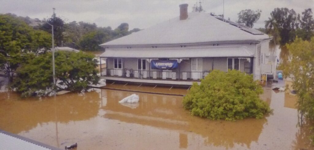
My unit is flooding – there is water everywhere. I am trying to sweep it out, but it just keeps coming, and I don’t know where it is coming from!
Heidi Lane describes on the phone to her friend on the night of 25 February, as a giant waterfall was tumbling over the steps at the rear of her unit.
In February 2022, Gympie suffered its worst flood in 120 years, reaching 22.96 metres. It came devastatingly close to the highest record, sitting second to Gympie’s biggest flood in settlement history, which occurred in 1893.
After a significant drought culminating in the 2019-20 wildfires, Queensland experienced heavy rainfall in November 2021, leading to high soil saturation levels.
2022 started at Gympie with a drenching from ex-tropical Cyclone Seth from 7-9 January 2022. The system tracked down the Queensland coast, dumping heavy rain, mainly north of Gympie. Some areas like Gunalda and Mt Kanigan received over 500 millimetres in 24 hours. The resultant flash flooding caused significant damage.
Three stronger-than-usual weather systems led to a multi-day significant flooding in south-east Queensland from 22 February to 7 March 2022. A low-pressure trough in the Coral Sea brought warm, moist air from the ocean into the upper atmosphere and over the land. A blocking high-pressure system in the Tasman Sea held the trough in place for a protracted period. An unusually cold upper atmosphere weather system came across from the Great Australian Bight, condensing the moist air in the trough and causing large amounts of persistent rain.
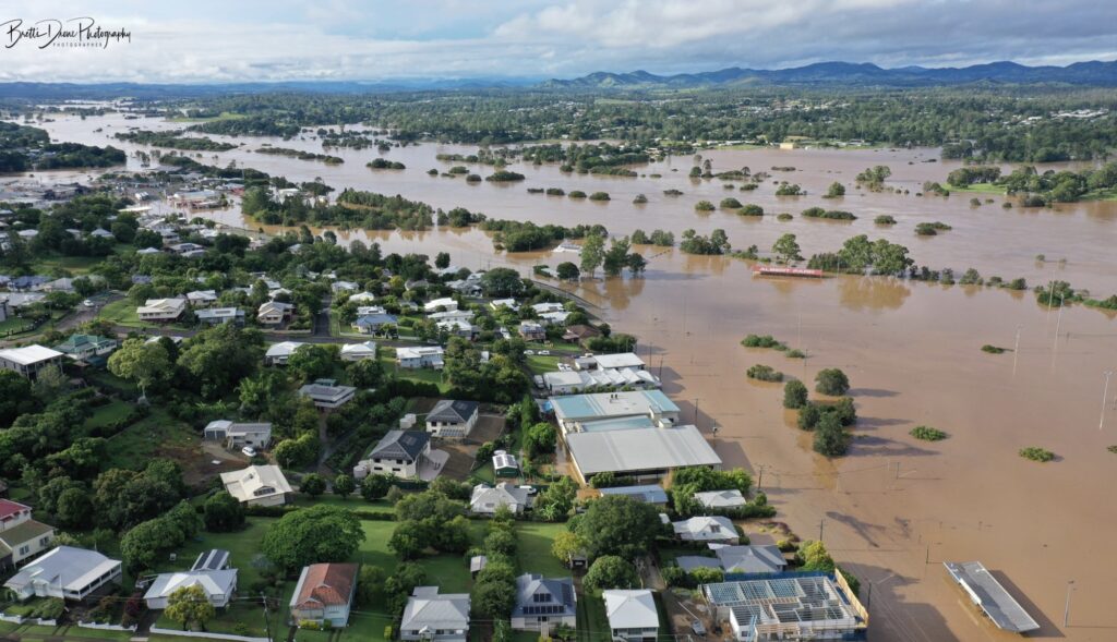
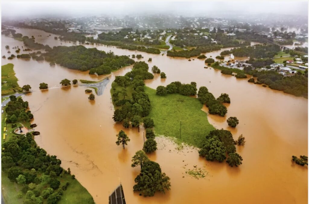
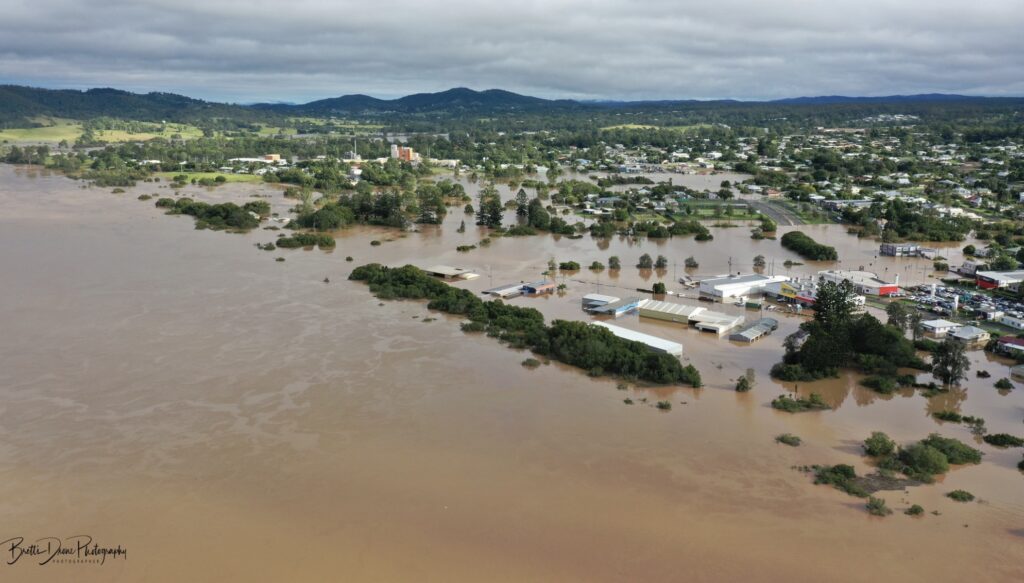
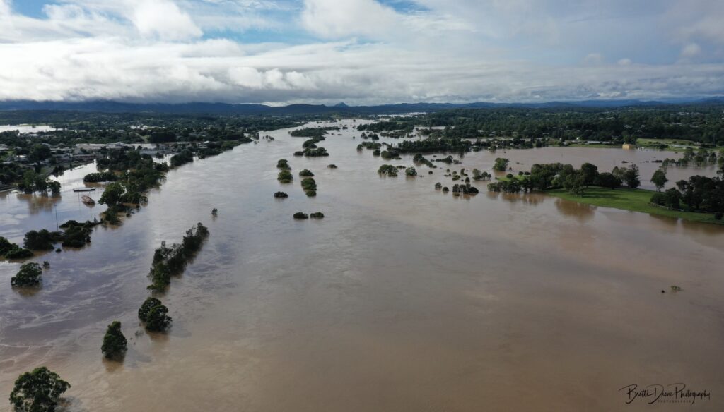
Looking south from Nelson Reserve. Photo Brett's Drone Photography and Media Productions.
The weather impacted the Wide Bay-Burnett Region, Brisbane, Northern Rivers of New South Wales, and the Greater Sydney Region. Prime Minister Scott Morrison declared:
These are floods that we have not seen in living memory in anyone’s lifetime, and even before that.
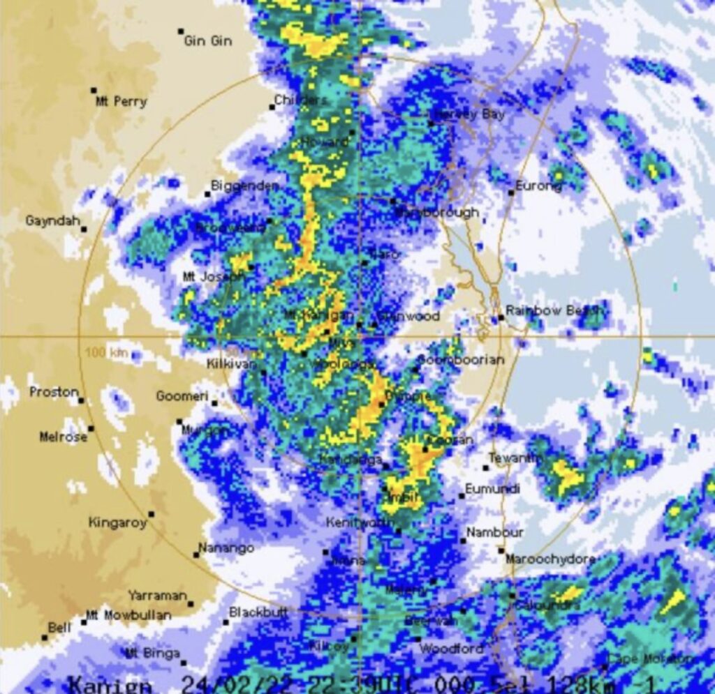
The Bureau of Meteorology (BOM) issued its first potentially heavy rainfall forecast for south-east Queensland on Monday, 21 February 2022. The next day, Gympie experienced severe thunderstorms. The first flood watch was issued at 2:45 pm, and a severe weather warning for Gympie and Kin Kin was issued for intense rainfall at 10:32 pm that night. Intense rainfall of 104 millimetres per hour was observed at Mount Wolvi. A further severe weather warning was issued for the whole south-east coast and parts of the Wide Bay-Burnett Region at 10:54 pm, and at 11:21 pm, the first flood warning was issued for the Mary River.
Mount Wolvi, about ten kilometres east of Gympie, recorded 425 millimetres in the 24 hours to 9 am on Wednesday, 23 February 2022 and a further 332 millimetres in six hours on Thursday, 24 February. A major flood warning for the Mary River was issued on Wednesday. Some local properties recorded over one metre of rainfall that week alone.
BOM image showing intense rainfall on the morning of 25 February 2022.
If that wasn’t enough for the residents, the trough and low-pressure system deepened between 25 February and 27 February. It remained slow moving, delivering persistent heavy rainfall, with pockets of very intense rainfall associated with thunderstorms. This was directly over Gympie and surrounding districts.
On 26 February, the Tin Can Bay rain gauge recorded 444.4 millimetres. The next day, a disaster was declared for the Gympie District, with the Mary River peaking at 22.96 metres at Gympie, the highest for over a century. Many areas recorded over a metre of rainfall during the last week in February.
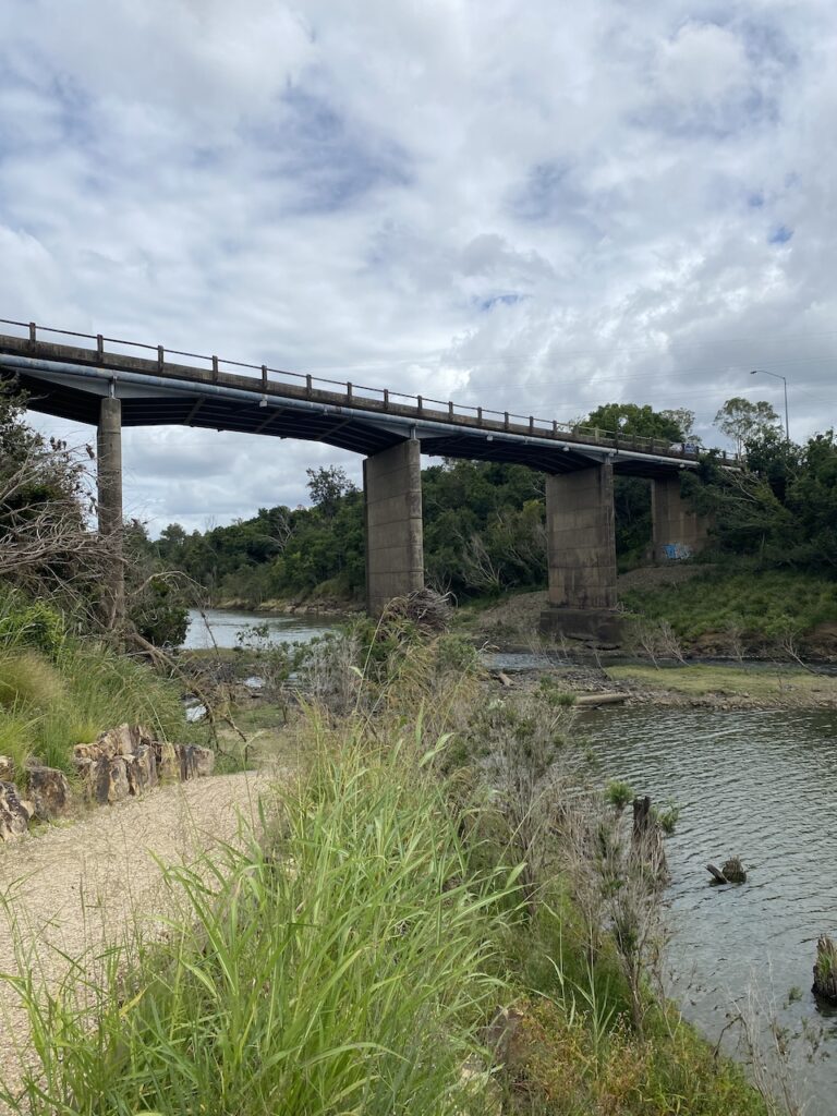
This photo shows the height of the Normanby Bridge above the Mary River.
Prior to the Normanby Bridge closure. Photo Gympie Regional Council.
After the closure of the Normanby Bridge. Photo Gympie Regional Council.
Two people died in the Gympie flood event. Phil Sugg died after driving through floodwaters on Tin Can Bay Road near Goombarian on 25 February. Philip Lambert died on 23 February when he was washed away trying to ride his motorcycle home at about 1:30 am along the Cedar Pocket Road. His body was found the next day.
During the 2022 flood, over 500 people had to seek refuge and shelter at the Gympie evacuation shelter, and up to 3,600 homes were inundated in the city, with 240 declared uninhabitable.
Gympie’s greatest-ever flood
“A legend that will persist into the future until, perchance, someday there occurs a still greater flood.”
Bill Mulholland.
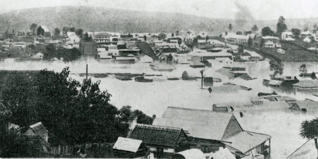
Gympie's 1893 flood.
There were several major floods during the 1890s – 1890, 1893 and 1898, which were very wet years. The flood heights for each year, respectively were 19.28, 25.45 (the record) and 22.0 metres.
In 1893, three cyclones crossed the Queensland coast – one in late January and the other two in February, producing some of the most devastating flooding ever recorded in the state. After the Brisbane River broke its banks three times that month, it became known as the Black February flood.
View of Commissioner's Gully under flood, 1893.
In late January 1893, a severe tropical cyclone that hovered out to sea for several days crossed the coast north of Yeppoon and suddenly struck southwards towards the south-east coast between Maryborough and Brisbane and inland as far as the Blackall Range, merging with an east coast low. It was known informally as Cyclone Bundinyong after the ship that recorded the low pressure near Mackay. Around 13 February, a second cyclone crossed the coast between Bundaberg and Hervey Bay, causing minor flooding. Another larger cyclone on 19 February, repeating the devastation of the first, crossing the coast south of Agnes Waters. Many coastal areas of Queensland, such as Rockhampton, Maryborough, Gympie, Ipswich and Brisbane, felt the destruction.
Heavy rain fell on the already drenched countryside. The Mary River began rising on 30 January and continued to rise. By 3 February, water levels rose “about ten inches an hour” to reach just over six metres deep in Mary Street. The flood waters peaked at 3 am on 4 February at 25.45 metres.
A total of 934 millimetres fell in February, a record monthly total.
Newspapers reported as many as 120 houses floating down the river and many more with only the tops of their roofs visible. In one famous incident, a home came to rest where the Nestle Tennis courts are now. After the water receded, the owners placed new stumps underneath it, and several generations of the family occupied the place until it was replaced in the 1970s.
The gold mines were severely affected. After the 1890 flood, a floodgate system was devised to prevent water from entering low-lying shafts. Steel frames were inserted into the mouths of all mines below the level of the highest known flood at the time, plus ten feet. However, the flood peaked at a higher level. The compressed air in the shafts exploded through the floodgates, and the mining industry took years to recover.
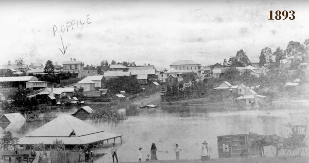
View of One Mile and Monkland taken from Red Hill during the 1893 flood. Photo Philp Family Collection.
Why is Gympie so flood-prone
Floods have become synonymous with Gympie’s identity. The town developed on a floodplain around a busy goldfield over 150 years ago. Creeks in the area that are dry most of the year can suddenly rise, crossing river flats and causing significant damage to structures in their path.
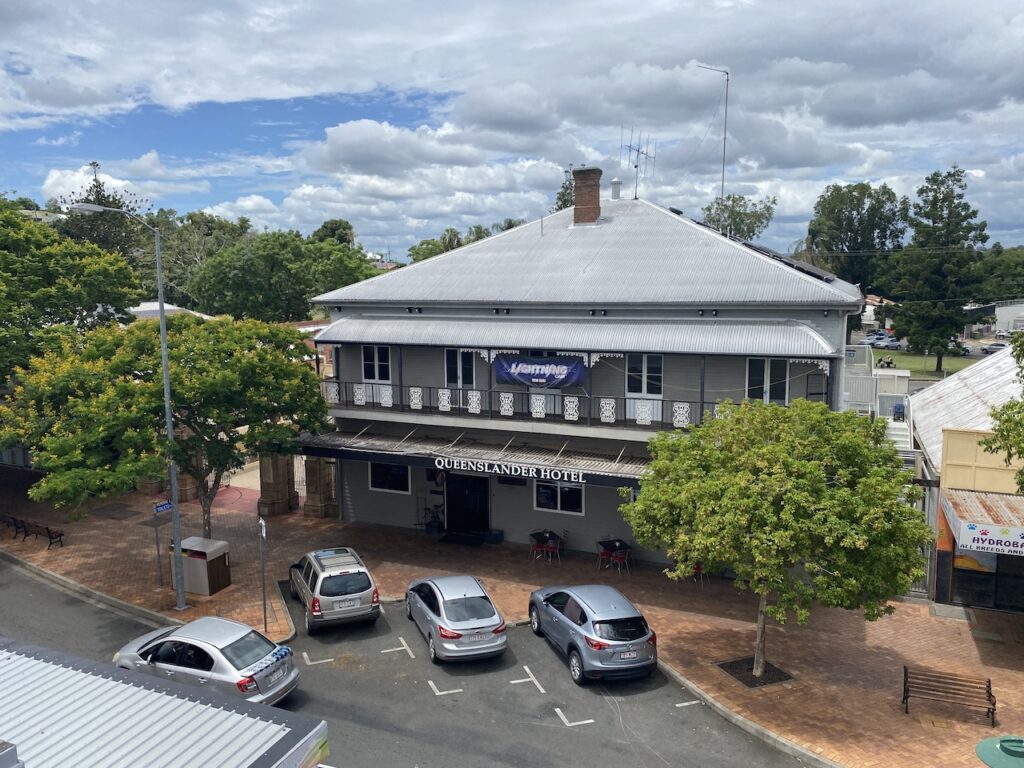
The Queenslander Hotel in Mary Street. Left, shows hotel in normal conditions and right shows flood height lapping the second floor during the 2022 flood. Right photo courtesy Gympie Today Pty Ltd.
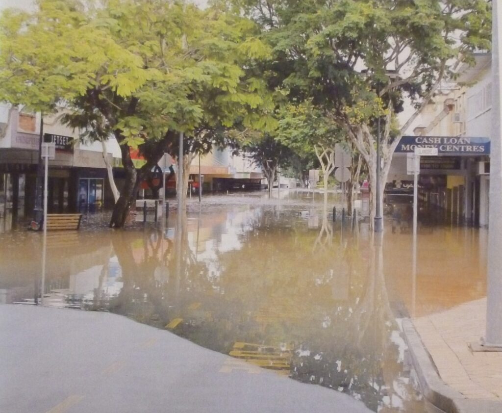
The historic centre of Gympie, today known as the “Fiveways”, was once part of a watercourse known as Nash Gully. Traditionally, after heavy rain, water backs up into Nash Gully, inundating the main commercial area and damaging low-lying parts of the town, affecting many small businesses. Flooding in Mary Street happens when the flood gauge at Kidd Bridge exceeds 17 metres. This has occurred more than 12 times in the past 50 years.
Many of the town’s floods typically come from drenching and torrential rains that travel south from cyclones in the tropical north during summer. Nearly 80 per cent of floods have occurred between December and April.
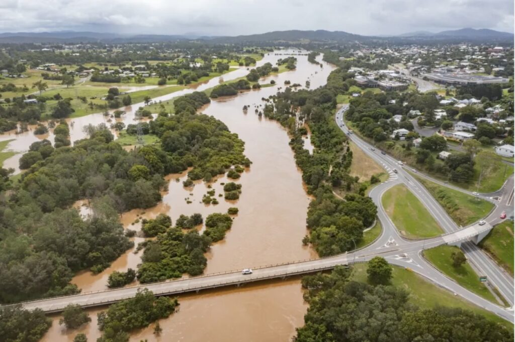
Archery Park, north of Kidd Bridge at 8:00 am on 27 February 2022. Photo Brett's Drone Photography and Media Productions.
The Mary River catchment covers an area of over 7,000 square kilometres. The headwaters of the river are in high rainfall areas in mountainous country around Maleny, Mapleton and down to Kenilworth. Heavy rainfall in these headwater catchments will likely cause major flooding in the Mary River downstream at Gympie.
For Gympie, 2022 was a very wet year. The yearly rainfall total was 1,605 millimetres compared to its long-term average of 1,116 millimetres. That year, the town experienced significant rainfall and flooding events – flooding in late December and early January from ex-tropical cyclone Seth, the major February flooding in February, and further flooding in May and July.
After water levels rose to the second level of many shops along Mary Street in February 2022, the Gympie Chamber of Commerce floated the idea of moving the city’s historic CBD out of flood-prone areas. However, there is too much infrastructure just to move.
Many new businesses have moved in to take their chance filling shops vacated by previous tenants, which have been devastated too many times. Gympie is a growing city, and its heritage buildings on Mary Street make it extremely attractive to business owners despite their age. It shows remarkable resilience but is it a wise thing to do?
Flooding begins in Mary Street.
People can find ways to cope if they do it with open eyes and understand the risks. That attitude is exemplified by one couple, who recently opened a bar in the heart of the flood zone:
We have flood insurance and have made everything assessable to shift out the door and go to a shed if it floods.
Their pragmatic approach underlines the town’s spirit of “getting on with it” despite the risks.
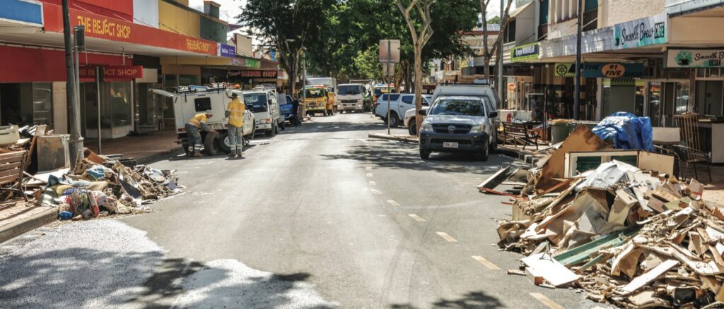
However, not all businesses were as fortunate. Many remained closed. When I visited the city four months after the flood, parts of the CBD felt eerily like a ghost town .
Cleaning up Mary Street after the flood.
Government response
Other places prone to regular flooding, like Lismore in northern NSW, are grappling with similar issues. The government has stepped in with a house-buying scheme to eliminate the most vulnerable houses from constant flooding threats.
Under a Commonwealth-State Disaster Recovery Funding Arrangement, residents in vulnerable flood zones have been offered assistance.
The program, backed by a $174 million Resilient Homes Fund, provides retrofitting services to make homes more flood-resistant, raising them above potential flood levels or, in some cases, offering voluntary buy-backs to those in the most exposed areas, aiming to reduce the number of people living in high-risk flood zones, and allowing them to relocate to safer places.
While the scheme was voluntary, it offered a lifeline to those who had suffered repeated devastation from flooding.
Like many flood-prone areas in Australia, Gympie faces an ongoing battle with nature. Whether through retrofitting homes or moving entire communities out of harm’s way, the conversation is shifting toward resilience. The floods of 2022 serve as a stark reminder of the increasing intensity of natural disasters and the need for long-term solutions.
Gympie’s 2022 flood was more than just a natural disaster—it was a community test of endurance. However, what remains unwavering is the spirit of Gympie’s residents, who continue to rebuild and adapt with resilience despite living under the constant threat of nature’s fury.
2 thoughts on “A rain bomb hits Gympie and surrounding districts”
John O'Donnell
Well done Robert. I have been going to to the Gympie Muster for 20 years and love the area.

Well done Robert. I have been going to to the Gympie Muster for 20 years and love the area.
CBC Gympie student 1957-1964.
The community lived with (out of manifest fear/apprehension of) an annual expectation.