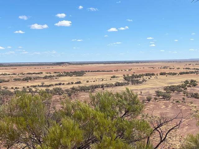
As you travel north from Winton to Cloncurry along the Landsborough Highway, you see spectacular open Mitchell grass (Astrebla app) plains with their distinctive golden colour under the relentless sunshine. I had heard about these magnificent plains but had no idea how extensive and beautiful they really are.
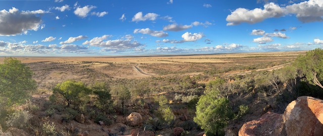
After McKinlay, you start to see a change in the soil from the black-grey clays to the red mineralised earth soils. There are more trees and shrubs. Spinifex is also more gradually evident on the roadside as well as on the mesas. Buffel grass (Cenchrus ciliaris), a deep-rooted, summer-growing perennial that is drought tolerant, has replaced native pasture grasses. Despite continually appearing fully cured and dry, buffel grass provides plenty of nutritious feed for livestock. A particular strain only found around Cloncurry is said to be the most nutritious.[1]
As I drive around the country, I try and assess the health or otherwise of the landscape. As we left the healthy Mitchell grass landscape and approached Cloncurry, I got the feeling that things were not in a great state. I saw plenty of turpentine bush (Acacia chisholmii), [2] This “unhealthiness” is not drought-related stress but more related to an explosion of shrubs across the landscape.
I spoke to an elderly lady who has spent her life in the Cloncurry district. She said that she lived on the southern outskirts of town in her younger years, and you had a clear view to the Cloncurry township. Today you can’t see the town through the shrubs. Shrubs limit visibility across paddocks, and the land is less manageable. Grasses don’t grow under the shrubs.
When Charles Sturt and others first explored the western rangelands in the 1820s to the 1850s, they described vast plains of open “meadows” and grass so thick and long “it was up to the horses’ middles”. Sheep and cattle flooded the plains, and an extraordinary transformation began.
The change in vegetation is well known and has been researched and documented. In NSW there was a Royal Commission in 1901 on the western lands.[3] Eric Rolls, in his award-winning book A Million Wild Acres, told the story of the growth of the “Pilliga scrub” in western NSW into a dense forest from an original landscape of open grassy plains during European settlement.[4] Early pastoralists noticed the expansion of native shrubs such as turpentine bush, hop bushes (Dodonaea spp), emu bush (Eremophila sturtii), and many others. Thickening in the mulga area of southwestern Queensland dates back to the early decades of last century. Inedible shrubs, mulga (Acacia aneura), cypress pine (Callitris glaucophylla) and eucalypt seedlings colonised bare, open spaces. The growth of ‘woody weeds’ was initially slow and not a noticeable problem. However, the growth had reached such proportions over time that three-year-old ringbarked areas became so unusable and uneconomic to treat, that the usual follow-up treatment of suckering, had to be abandoned.
The problems with shrub invasion have been summarised in a book called The Delicate and Noxious Scrub by Jim Noble.[5] Published in 1997, he documented the proliferation of native trees and shrubs in the semi-arid woodlands of eastern Australia.
I have carried the following two photos in my collection. They show the transformation of open woodland to a closed forest of shrubs at Wongalee Station, in the Charleville-Bollon mulga area in south-west Queensland. It is an excellent example of what is happening on the rangelands. The photos were taken 37 years apart in 1957 and again in 1994.
But what exactly are the causes of this imbalance that has occurred across the rangelands?
Fire once kept the country open. Aborigines practised a form of land management for millennia that favoured open grass plains and woodlands. Above-average rainfall in the 1860s and 1870s coincided with the early pastoral expansion. As early as 1911, Czech botanist Karl Domin stated that, in all parts of Queensland, the open “forests” were not natural but a secondary one changed by Aboriginal management.[6] Grassy flats recorded by station managers in the late nineteenth century are now covered in box seedlings due to the absence of fire. Despite all the attention and knowledge about fire management, the use of fire to manage the tree-grass balance in the rangelands is rare.
Noble linked the disappearance of the herbivorous burrowing bettongs or rat-kangaroos (Bettongia lesueur) with the late nineteenth-century spread of scrub across the western plains.[7] Bettongs are no longer found on mainland Australia, despite a previous widespread distribution. They promoted a diversity of herb plants across the landscape. They excavated distinctive warrens with a horseshoe-shaped perimeter mound and sustained a diverse and nutritious forage for larger herbivores in their role as landscape engineers. They could also maintain vast areas of grassland by eliminating shrubs. They were mainly present on the red earths in mulga-dominated landscapes and were rare in the heavier textured clays of the Mitchell grass plains.
Another factor has been the introduction of myxomatosis in the 1950s and high rainfall seasons in the 1950s, 70s, 80s and 90s. Rabbits, particularly in the softer red earths, took over many of the bettong warrens and decimated the native pastures and herb species, in concert with introduced livestock. Their demise in the 1950s allowed aggressive shrub species to gain a foothold in the landscape.
In a lot of ways, modern pastoralism fostered the scrub spread. Artificial watering points sustained intense grazing by livestock, feral animals and kangaroos. The livestock focused on the grasses and edible shrubs. Water stored in tanks and troughs sourced reliably from the underground artesian basin lasted longer than the palatable herbage. Sheep, in particular, were good at eliminating perennial vegetation that typically survived droughts. High wool prices in the 1950s and 60s exacerbated the problem. Pastoralists introduced more watering points and raised stocking rates. Drought-breaking rains favoured the germination of inedible plants once wind and water depleted the diverse seed store. What followed was the spread of invasive shrubs.
Contemporary rangeland studies started in the early 1970s. Queensland rangeland scientist and fulltime grazier in the mulga country, Ian Beale, was at the forefront of research and development work on tropical grasslands. Contrary to the study methods used by his CSIRO colleagues, Beale adopted the forester’s practise of measuring tree competition in terms of stem basal area. It is a robust measure used in most of the tree-grass studies that followed. Beale’s and other subsequent studies showed relationships between trees or shrubs with pasture for a range of woodland sites in Queensland and north-west NSW. This work helped applied ecologists understand the close relationship between tree basal area and pasture production.
I strongly recommend readers look up a compendium that brings together much of the evidence of vegetation change since European settlement that was published nearly 20 years ago.[8] This compendium highlights the value in another tool that foresters use – aerial photo interpretation (API). Foresters have known the value in using aerial images since World War II, but plant ecologists have underestimated its use. Going against that orthodoxy, plant ecologists Rod Fensham and Russell Fairfax recognised what foresters already knew and argued – that API was an underrated means for assessing vegetation dynamics. For example, Fensham, using API, claimed to accurately quantify an average basal area increment of 21 per cent in uncleared eucalypt woodland remnants in central Queensland from 1952-1991. While satellite imagery has become the tool to use these days, it does not have the time scales of aerial images. In my book Fires, Farms and Forests, I refer to a 1903 survey plan of Surrey Hills in north-west Tasmania. The surveyor was required to map the vegetation communities on Surrey Hills at that time, and it serves as an important historical record of what the vegetation was like before aerial images and other more modern aids. It can be used in conjunction with aerial photos from World War II to provide an accurate picture of the changes in the landscape. For Surrey Hills, the removal of Aboriginal land management disrupted the stability of the unique and sharp grassland-cool temperate rainforest boundaries. Today, there is a growing concern over the spread of hakea shrubs over the grasslands which are replacing the native Poa grass.
Government regulators and greenies dismiss this whole problem about the negative effect that tree-grass competition has on pastoralism. This changing landscape has become a political battleground. Scientifically-proven observations of a general thickening and encroachment of woody vegetation are ignored. In Queensland, the fundamental basis of the clearing controls focusses on the conservation status of regional ecosystems. Bureaucrats compared the remaining percentage of each ecosystem with that allegedly present in 1788. The government adopted this analysis and introduced clearing laws based on guesstimates that ignore the constantly evolving floristics and structural responses across the rangelands since European settlement. The greenies and bureaucrats think nothing has changed in the rangeland landscape since 1788 – they believe the landscape is static. They mapped the ecosystems for 1788 based on what we see today – a more treed and dense landscape. They have ignored the explorers’ first-hand accounts of what they saw and surveyors’ records of a much different landscape than today. It is surprising that after more than 150 years of pastoralism, there is still debate over the scientific evidence that clearly shows a significant structural change in most woodland communities since livestock grazing commenced.
Opponents of tree and shrub clearing in rural Australia portray a myth that pastoralists are recklessly and wantonly clearing vegetation that was present at the time of European settlement. This is so far removed from the truth. The clearing figures quoted are often inflated because they include clearing permits that pastoralists apply for but do not use. The public does not realise that areas cleared today were also cleared 20 years earlier, and a further 20 years before that. In other words, this dynamic landscape, now overrun by invasive shrubs and a woody biomass explosion, is an artefact of European settlement, not a remnant landscape.
The debate about land clearing in Queensland has ignored the elephant in the room. Woodland communities protected from clearing will in time lose their livestock production capacity. Native grasses are disappearing, and bureaucratic controls hinder graziers who want to restore the landscape. Greenies and vegans may like what is happening, but this ignorance is replicated around the world. There is ample evidence that the planet is becoming greener with more plant growth, yet claims that trees and woodlands are disappearing are receiving more and more prominence. A growing body of evidence provides a different story. A study in 2018 examined satellite data and found that global increases in tree cover have more than offset losses over the past 35 years through natural regeneration, not planting.[9] It is all about CO2 fertilisation. As CO2 levels in the atmosphere have increased, so too has the greening trends. Another study in 2016, again using long term satellite data from 1982 to 2009, showed a persistent and widespread increase of up to 50% of the global vegetated area.[10]
What we see today across the millions of hectares of rangelands in Australia are the results of insidious changes that are not adequately recognised or acknowledged outside of rangeland management. This phenomenon is not unique to Australia. It has occurred around the world.
Today’s thinking on the rangelands is about restoration and the removal of over exploitation, or at least, an attempt to understand the impacts of livestock on the land and manage grazing systems to enhance, not only productivity, but to bring the landscape into a healthier state. Invasive shrubs and woody vegetation need to be removed. Unfortunately, a myopic view on rangeland ecology by governments, greenies and academics prevents the implementation of appropriate management strategies to tackle this serious problem. The solution isn’t a one-size-fits-all no-clearing mentality for all the rangelands from Cape York to southern Western Australia.
There is no doubt that producers of food and fibre face a challenging hurdle to farm the rangelands sustainably. The debate is grossly distorted by academics, activists and ill-informed bureaucrats offering gratuitous and over-simplified solutions based on spurious data – a clear sign they have no understanding of the dynamics of rangelands.
[1] Buffel grass is widespread in northern and central Australia. It was accidently introduced by Afghan cameleers in the 1870s in north-west Australia. It is favoured by pastoralists because it is drought resistant provides high nutritional value for cattle. It can dominate the ground layer and displace native grasses and other plants. Buffel grass is invading semi-arid and arid areas. There are calls to declare it as a weed in these areas and control its spread.
[2] Quite a few Australian species bear the common name Turpentine bush. A wattle (Acacia lysiphloia), three euphorbs (Beyeria lechenaultia, Beyeria opaca and Beyeria subtecta) and three emu bushes (Eremophila Clarkei, Eremophila fraseri and Eremophila sturtii). In Queensland Acacia chisholmii is referred to as turpentine bush.
[3] Royal Commission (1901) Inquiry into the Condition of Crown Tenants in the Western Division of NSW
[4] Rolls, E. C. (1981) A Million Wild Acres: 200 hundred years of man and an Australian forest. Nelson, Melbourne.
[5] Noble, J. C. (1997) The Delicate and Noxious Scrub. CSIRO Publishing, Canberra
[6] Domin, K. (1911) Queensland’s plant associations: some problems of Queensland’s botanogeography. Proceedings Royal Society of Queensland, 23, 63–67
[7] There are many possible causes for the decline of burrowing bettongs. The reduction in traditional fire regimes changed their habitat. As pastoral leases spread over the rangelands, livestock reduced vegetation cover, shrinking their habitat. Foxes and cats were predators and rabbits successfully competed for shelter, and maybe food. The bettong was also declared a pest in Western Australia.
[8] Australian Journal of Botany (2002) Volume 50 , Issue 4
[9] Song, X-P et al (2018) Global land change from 1982 to 2016. Nature doi:10.1038/s41586-018-0411-9
[10] Zhu, Z. et al (2016) Greening of the earth and its drivers. Nature Climate Change doi:10.1038/nclimate3004
Very good reading Robert
Good one (well referenced)😊