As we travelled around Australia, I was amazed at how many towns we came across that had shifted for whatever reason. While I already knew about a few, I had no idea many towns were forced to move.
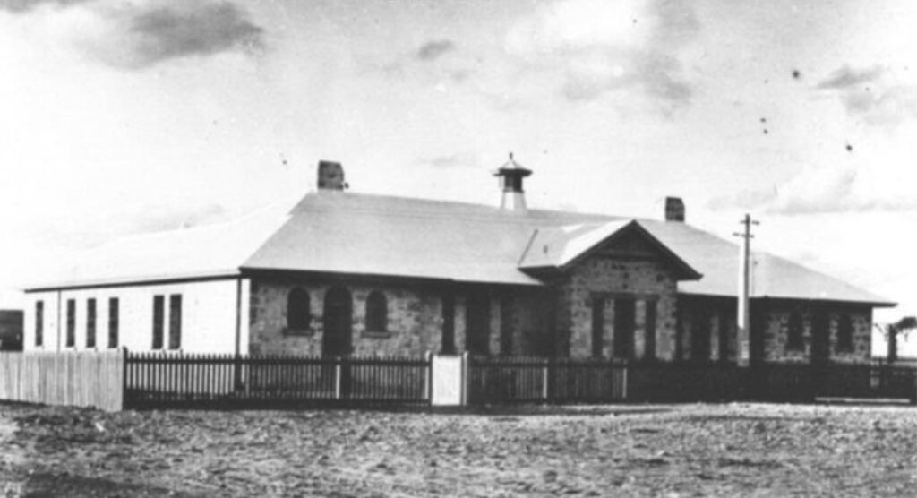
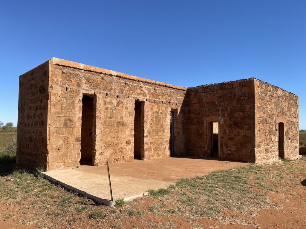
Probably one of the best-known is Eucla on the Nullarbor Plain. The Eucla Telegraph Station opened in 1877 and helped link Western Australia with the rest of Australia and the world.
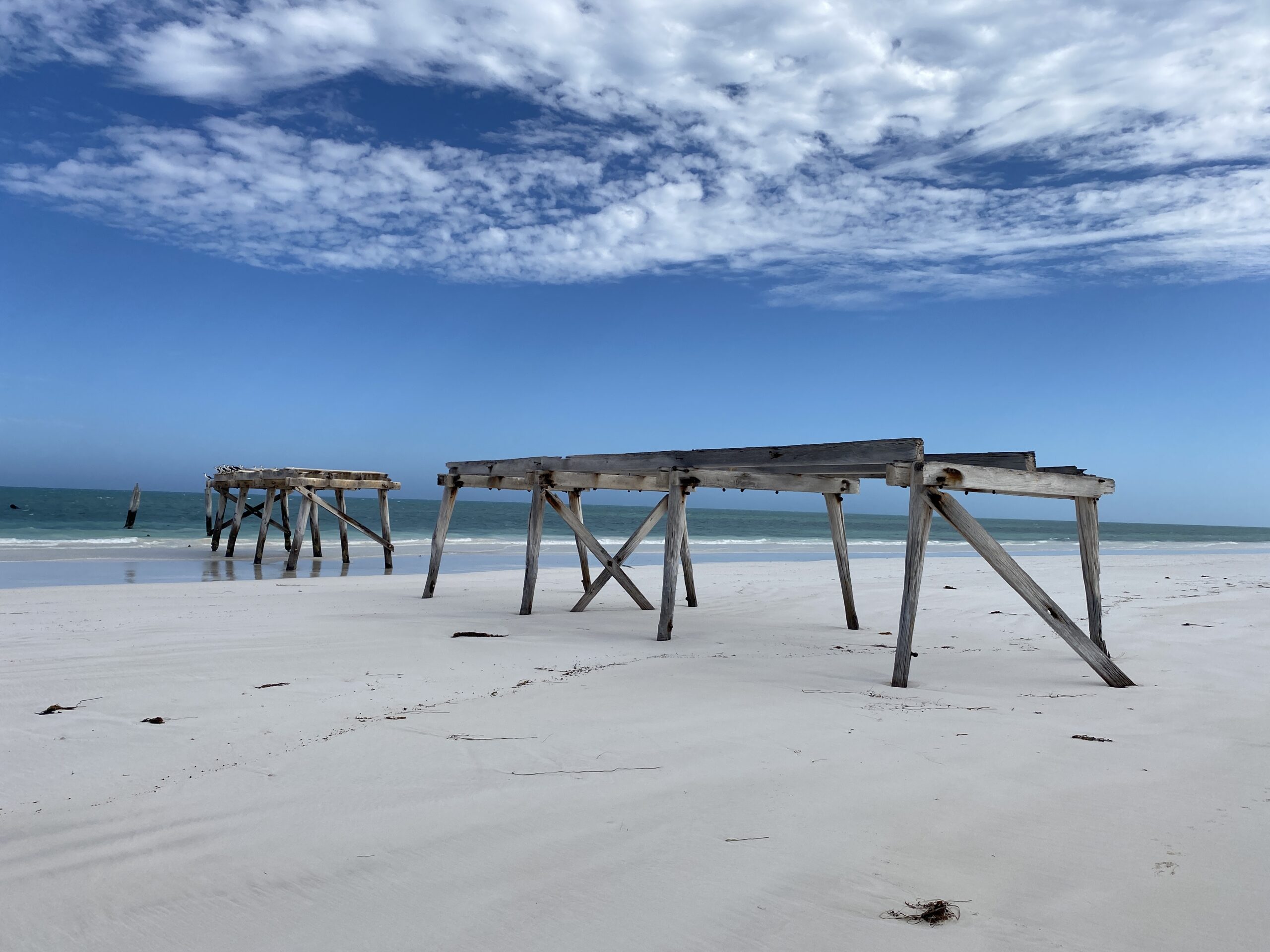
Situated a few kilometres across the border of Western Australia, visiting the Eucla Telegraph Station is just one of the many things you should include in your adventure while crossing the Nullarbor. The constantly changing landmark is little more than a few old stone walls protruding above the moving dunes.
Originally, Eucla’s Delisser Sandhills were considerably smaller than today. Then, in the 1890s, a rabbit plague passed through the area, eating dune vegetation which caused large sand drifts that repeatedly covered and uncovered the telegraph station. Today the telegraph station remains in ruins.
By the time the telegraph line was abandoned in 1924, replaced by a much more easily maintained line along the new transcontinental railway, the rolling dunes were closing in, slowly engulfing the town.
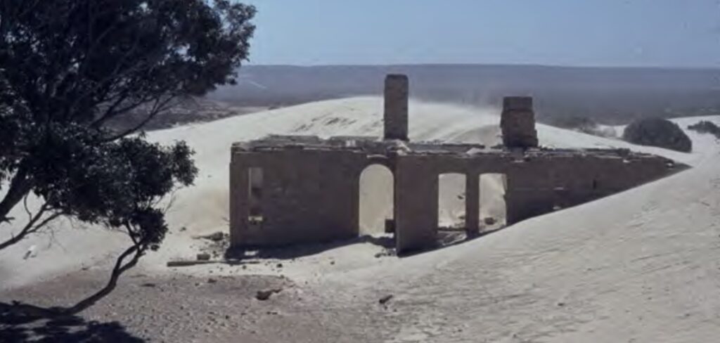
The sand movement caused the town’s abandonment, and a new town was built four kilometres inland, on higher ground near the Eucla Pass. Eucla is now an important traveller stop on the Eyre Highway, with good facilities including fuel and accommodation.
Ruins of the original town, limestone buildings, and the remains of the jetty can still be seen in the sandhills south of Eucla.
Towns have had to shift due to proposed flooding from the construction of new dams.
Happy Valley in South Australia had to relocate after the government decided to build the Hope Valley Reservoir in 1872. They moved the township east, while the cemetery and graves were shifted west and relocated alongside the dam wall. The reservoir was built between 1892 and 1897 and is one of two metropolitan reservoirs providing Adelaide’s drinking water.
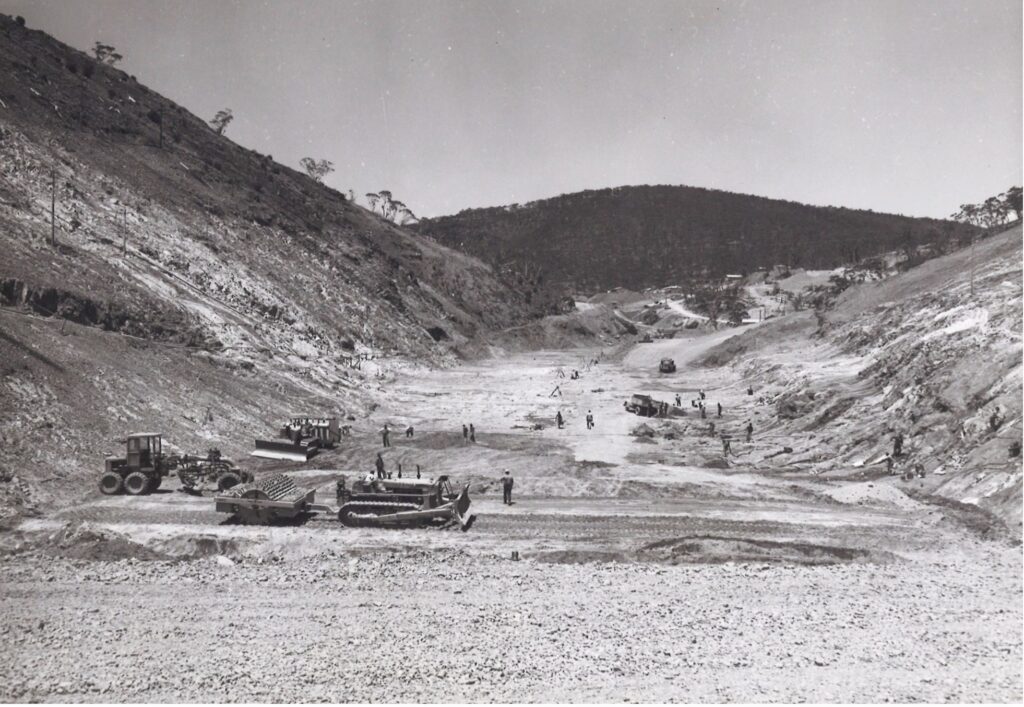
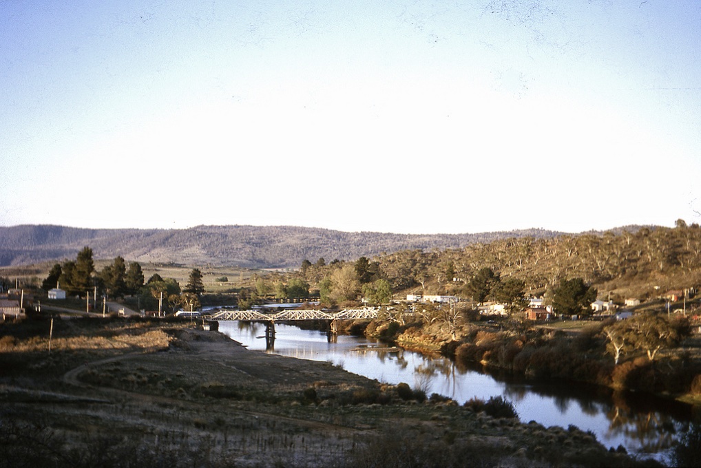
Adaminaby was shifted in 1957 to make way for the construction of Lake Eucumbene, a dam built for hydropower generation as part of the Snowy Mountains Hydro Scheme. The original dam proposal had the waters rising to just below the town, resulting in it becoming a lakeside town. A lavish opening ceremony was held in Adaminaby in 1949 to commemorate the first explosive blast for the first and largest of the scheme’s 16 dams.
Because the Governor General and Prime Minister attended, a ceremonial plaque was erected.
However, after further investigations and engineering work, the Snowy Mountain Authority chose a second site for the dam wall, six kilometres downstream, to allow for greater water storage. Unfortunately, it meant that a significant portion of the town would be flooded and would have to be relocated. It was a challenging task for the Authority, who were treated with disdain and suspicion by the locals. In addition, much of the land to be flooded was prime grazing land, and the Authority had to offer generous compensation for displaced residents and farmers.
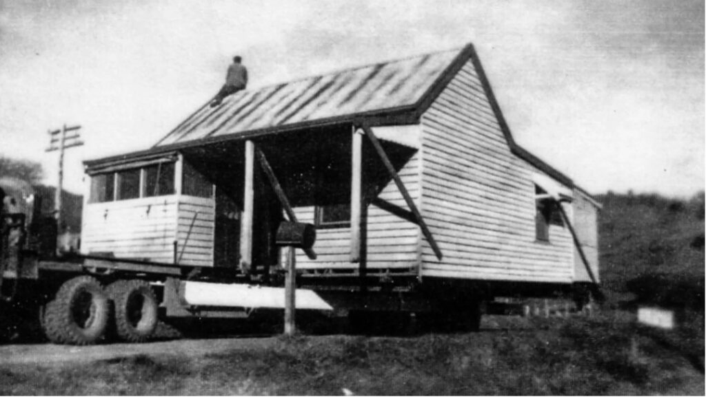
Relocations began in 1956, with 102 buildings and two stone churches moved. Four buildings that were above the high-water mark stayed where they remain today. Unfortunately, many historic Victorian-era buildings and artefacts were lost, and no one made any effort to record the town before its destruction. Only 250 people moved to the new location nine kilometres away over the Great Dividing Range. In a sad irony, the ceremonial plaque unveiled by the Governor General and Prime Minister was submerged beneath several metres of water.
Tallangatta, a north-east Victorian town, was moved eight kilometres west to a site known as Bolga in the 1950s to make way for the expansion of the massive Hume dam. More than 100 houses were moved to the neat geometric layout of the new location. Carmyl Winkler wrote a book about the relocation called Slates and Suet Puddings. Consequently, the town is now known as the one they couldn’t drown.
Jindabyne is another town in the Snowy Mountains that was transferred to its present location in the 1960s. It was due to the construction of Lake Jindabyne as part of the Snowy Mountains Hydro Scheme. Jindabyne was initially situated on the banks of the Snowy River, where the main river crossing was for cattle travelling between the Monaro and Gippsland. After a bridge was built in 1893, the town thrived. In preparation for the move, plans got underway in 1959 to shift the 250 residents, but the Authority only relocated a few houses. Residents held a symbolic farewell to the old town in December 1964, where they crossed the bridge for the last time and walked up the hill to their new homes. In 1967, an army demolition team blew up the bridge signifying the end of a link to pioneering heritage.
A small town called Doon was established in the 1870s on the Goulburn River in Victoria. It was renamed Bonnie Doon in 1891. A railway was built in the same year linking the small town to bigger cities. Unfortunately, the construction of Lake Eildon in the 1950s led to the relocation of Bonnie Doon to higher ground near the Anglican and Presbyterian churches.
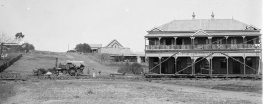
Sometimes the original town was in an inappropriate position. Take Maryborough in Queensland, for example. It is located on the lower reaches of the Mary River. Originally the town was placed on the north bank past the major bends on the river past Tinana Creek, about four kilometres north-west of the current location. However, to allow for easier port access to bigger ships, the settlement was moved downstream a few kilometres from the original wharves to its present location. The irony is that its current location, on the flood plain of a significant river bend near Tinana Creek’s mouth, is subject to severe flooding.
The original settlement of Onslow, a coastal town in the Pilbara region of Western Australia, was established at the mouth of Ashburton River in 1883 to serve the hinterland pastoral industry. A seawater jetty was built and serviced the town via a four-mile tramway built over marsh and sand hills. Unfortunately, successive cyclones damaged not only the jetty and buildings in town but caused the build-up of sandbars which created obstacles in the shipping channel.
Those in charge decided to develop a deep-water port at Braeden Point, 20 kilometres to the north-east where the town of Onslow now stands. A new jetty was completed in 1925. However, remnants of the old town remain, and it is worthwhile visiting.
Another town that had to shift from its original location to a better spot is Wyndham in the Kimberley region. The town was first established in 1886 as a major port and trading station for the East Kimberley area. It is the most northerly township in Western Australia, surrounded by spectacular landforms, rivers and wetlands.
However, it refused to grow in the right place. Government surveyors prepared a townsite three miles from the original wharf, but the gold diggers camped where the traders dumped their stores, and the early settlement grew up around them. The port was essential, being the only deep-water port within the Cambridge Gulf. But the town struggled to expand due to the tidal mudflats at both ends of the main street. For this reason, in 1968, the town was moved to its initially planned area three miles inland, and the old town was renamed Wyndham Port.
Sometimes towns moved because of new transport corridors. The original settlement of Halls Creek was the first payable gold discovery in Western Australia in 1885. As with all gold discoveries, a settlement developed quickly. From the original canvas tents to buildings. At its peak, the town had a hospital, post office, police station, stores and a hotel. After the gold rush, the small town continued to exist but was characterised by extreme isolation. Once the government built the only bitumen road in the Kimberley region, the Great Northern Highway, the town was relocated 15 kilometres west to its present site in 1948. The old township was finally abandoned in 1954 and now sits as a ghost town. The only activity in the area is associated with a small caravan park mainly used by gold fossickers.
Some towns have moved because of flooding.
The deadliest flood in Australia’s recorded history occurred in 1852, which swept through the New South Wales town of Gundagai. The water rose quickly, sweeping away buildings. Between 80-100 people died. Gundagai was gazetted as a town in 1838 on the low-lying river flats of the Murrumbidgee River. In the aftermath, the government agreed to exchange allotments at risk of flooding on higher ground. By the end of 1859, the old town was abandoned entirely, and Gundagai was settled on the slopes of Mount Parnassus, where it sits today.
The Central Queensland town of Clermont was relocated to higher ground after a flood in 1916 killed 65 people. Because it was built next to a lagoon on low-lying land, they decided to move the town after the flood. Many existing buildings, including the pub, were moved by stream traction engines to higher ground.
The border town of Texas was initially located on the banks of the Dumaresq River in Queensland. The famous flood of 28 March 1890 wiped out the tobacco factory and the town itself. Sections were moved two kilometres north to higher ground. Another flood in 1921 forced parts of the low-lying sections of the town to move to higher ground. There are just a few remains of original Texas on the banks of the Dumaresq River.
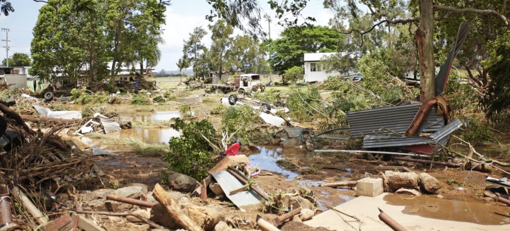
The town Grantham in the Lockyer Valley, Queensland, was hit by a three-metre wall of water from a flash flood on 10 January 2011, killing 12 people, tearing houses and buildings from their stumps and changing the fabric of the town forever. After only 11 months and $18 million, the residential part of town was reborn on a hillside to the north-west, with 90 families moving. The commercial centre remains where it was on the highway. The local council purchased a 377-hectare site to enable a voluntary swap of equivalent-sized lots. In addition, the council streamlined the planning regulations to aid in the relocation.
After the devastating flood of the Hunter River in 1955, there was a proposal to shift Maitland to the high ground of East Maitland. A similar idea was entertained during the late 1820s after several floods. However, residents chose to maintain the advantage West Maitland offered with its bustling centre near the river.
Following the 2022 floods in Lismore, there were proposals to shift affected houses to safer areas, mixed with some buy-back options. As I write this blog, there is no agreement on a definitive solution, even though relocating the city has also been mooted.
Are there any other towns in Australia that have relocated for whatever reason?
Very well researched. Gympie is one town that should have been moved.
Rob
Your latest travel blog made quite interesting reading. Gold prospecting was once a very common reason for a “town” springing up, only to disappear entirely a few years later.
Here is a travel story of my own:
MOUNT PLEASANT
Daylesford was a mining town from the very commencement of the Victorian gold rush, alluvial gold having been found there in 1851. It was originally known as Jim Crow because it was formed at the junction of Jim Crow Creek and Spring Creek but the name changed soon to Wombat Flat Diggings and eventually to Daylesford. A second influx of miners arrived in 1855 but enthusiasm dwindled; it was a cold, wet and isolated area with a lot of work needed to clear the dense forest before any mining could start. The third rush in 1856 was more successful and several fortunes were made, many by a group of Swiss miners.
Mount Prospect is about 10 km southwest of Daylesford and its history has a mining origin. The names Blampied and Mount Prospect have been used alternatively to describe the place. During and after the gold rush of the 1850’s immigrants from all over the world settled in the area and there were hotels on every corner to cater for this polyglot lot. Henry Newton, a nephew of my great grandfather owned one of the hotels in 1899.
In November 2004, I journeyed to the area. I anticipated finding a town with streets and many pubs. There was no town! Blampied and Mount Prospect are today just two dots on a map, separated by one country road of about three kilometres in length. Near the northern end of the road I could see the Swiss Mountain Hotel – still in use – but no other buildings existed in 2004 to suggest that a town was ever nearby. Travelling down the country road, I came to a crossroad called Telegraph Road. Today, there is nothing but farmland all around. On the northeast corner of the intersection there is a farmhouse and across the intersection, on the southwest corner, stands a disused old tennis court. My gut feel is that the Telegraph Hotel was once on the site of this tennis court.
Robert,
Bega as well. Refer link.
https://www.dailymail.co.uk/news/article-10670909/How-four-Australian-towns-relocated-floods.html
The Gundagai flood disaster is important, the Aboriginal people rescued a heap of people and were not acknowledged for a long time. They knew, just as much as the Aboriginal people knew in the Warragamba area when an early explorer asked about flood rack.
We haven’t heard the last in regards to Lismore, flood mitigation is a critical issue for that community and hopefully the CSIRO whole catchment flood study provides solutions that governments at all levels will assist with in providing funds.
Towns move, but so do people, they often move away after floods, bushfires etc, another important issue.
John
Hello Robert, the original Pambula village had a very short history, before being shifted to higher ground. “Crown land sales in the new Pambula township took place in 1851. However, those sections of the proposed town nearest the river were flood-prone and did not develop. A major flood in 1851 washed away the small settlement and so the township was moved onto the higher ground to the north.”
Two more Western Australian ones for you Robert. If you’ve ever travelled up the Brand Highway you would have gone past Badgingarra. This is ‘new’ Badgingarra – it was moved several kilometres west to lie on the new highway (in the 70s I think), although I think I’m right in saying the school has always stayed at the ‘old’ township site.
Secondly, and this is a bit more tenuous – Fitzroy Crossing in the early years used to be the old telegraph station which was on the eastern side of the river at Blue Bush Swamp (now part of Gogo Station I believe), but the local copper (Constable Pilmer) chose to build his police station on the western side because it seemed the better option during any floods. Charles Blythe also was granted an innkeeper’s licence around this time and set up shop near to the copper’s residence (a wise move), so the ‘town’ was essentially split in two, with the Old Fitzroy Crossing being the link. With time all the eastern-side people mostly gravitated to the western side. So, not so much ‘moved’, as just an originally poor decision about where the telegraph station should have gone was remedied.