“The dead ash forests reach starkly towards the sky like sentinels bearing witness to the holocaust just past, and those who love the bush are heavy hearted because this may be only the beginning of what is yet to come.” David Treasure, 2007[1]
Since 1939, the high-country forests in Victoria were relatively free of devastating wildfires.[2] The only other major fire was at Mount Buffalo and surrounding areas in 1984 which threatened the small town of Wandiligong. Things changed in January 1998 when 35,000 hectares of the foothill, sub-alpine and alpine vegetation burnt in the Caledonia River fire. The fire became a portent warning for what was to come. The Victorian Alps have been exposed to as many as four different severe bushfires this century that has decimated the integrity of the forests to maintain themselves into the future. Heavy fuel loads that were allowed to build up over many years produced high-intensity fires that were unstoppable. Some commentators have directed blame for the fires solely on climate change. I believe there are more fundamental reasons for the fires and current management structures need to change.
Introduction
During March this year, my wife and I enjoyed magnificent autumnal weather while we were in north-east Victoria. We spent time cycling on the rail trails and visiting the alpine country at Mt Buffalo and Mt Hotham. While driving through the Ovens Valley, we saw ridges clad with stands of native forest, as well as pockets of pine plantations around Myrtleford and Bright.
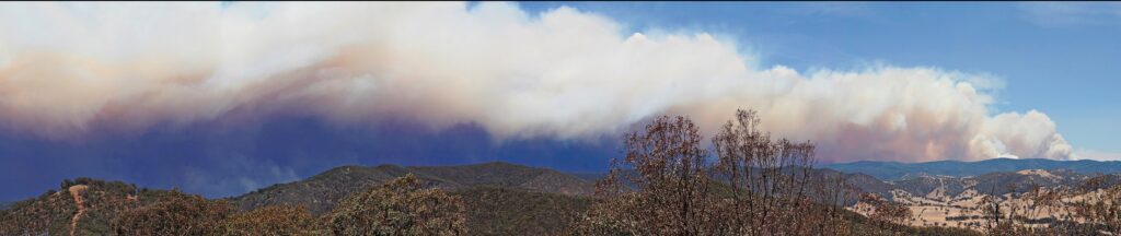
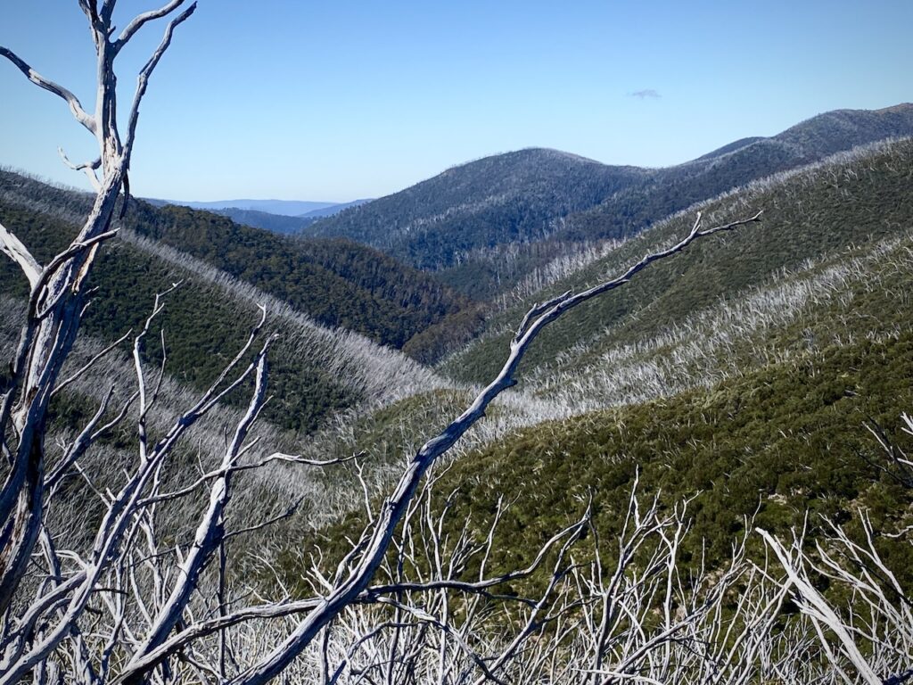
It is not until you start climbing the alpine roads to reach the iconic tourist places at higher altitudes that you are reminded of the devastating fires this century. Travelling through the burned forest on the Great Alpine Road is a sobering reminder of the damage of high-intensity fires. Between 2003 and 2020, nearly three million hectares of the mountainous, forested areas of Victoria burned in four different summers of varying intensities.[3] There are few forests one can visit without seeing a blackened landscape. Scorched leafless trees extend as far as the eye can see, bereft of bird songs. These fires are a direct result of a new land management ethic in Victoria – a ‘fire protection’ ethic that focuses ‘on the protection of assets rather than working with the whole ecomass’.[4] Nature will undoubtedly respond, but we may face a new equilibrium that will encourage frequent hot and severe fires unless government policies change drastically.
Fires, fires and more fires
| Year | No fires | Duration | Area (ha) | Damage | Main locality in NE Vic |
| 2003 | 87 | 59 days | 1.3 million | 41 homes, 9,000 livestock, kilometres of fencing | Mt Buffalo, Bright, Dinner Plain, Dargo High Plain, Omeo |
| 2006-2007 | >1,000 | 69 days | 1.2 million | 1 death, 51 homes, | Ovens Valley, Mt Buffalo, Buckland Valley |
| 2009 | 400 | 41 days | 430,000 | Dargo High Plain | |
| 2012-2013 | 1 | 55 days | 36,400 | 2 deaths | Upper Ovens Valley, Buckland Valley, Mt Hotham, Dinner Plain |
| 2019-2020 | 319,400 | 1 death, 4135 livestock | Dinner Plain, Mt Buffalo |
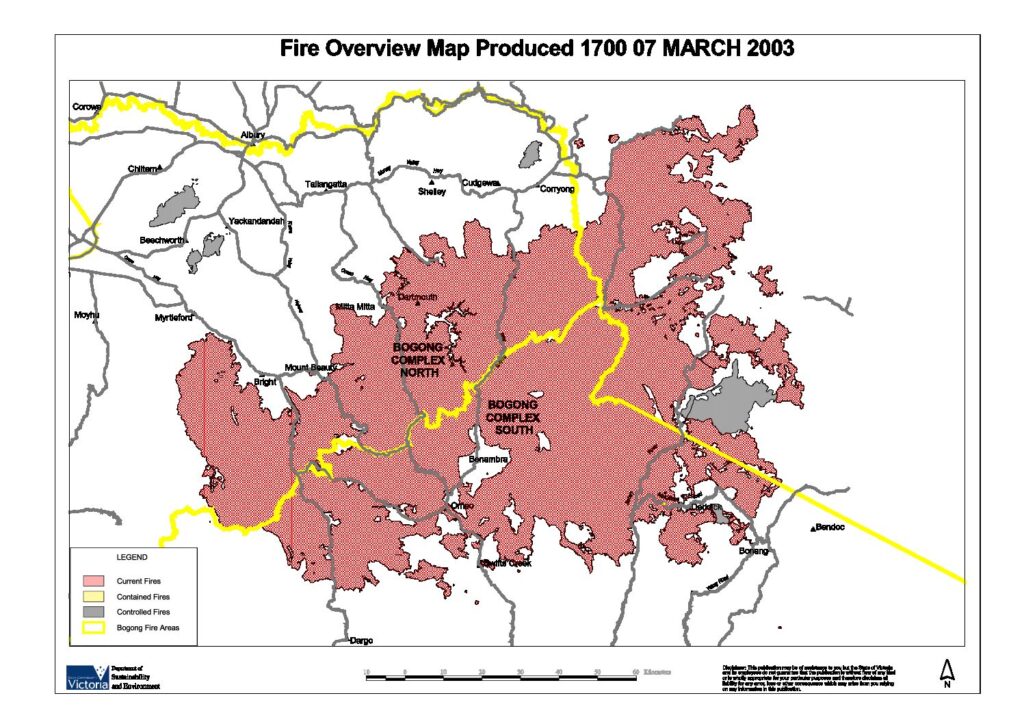
The 2003 Eastern Victorian Alpine fires originated from 87 fires started by lightning in north-east Victoria on 8 January. Eight of these were unable to be contained and joined to form the largest fire in Victoria since the 1939 Black Friday bushfires. The fires burnt in Mt Buffalo, Bright, Dinner Plain, the Dargo High Plains and Omeo.
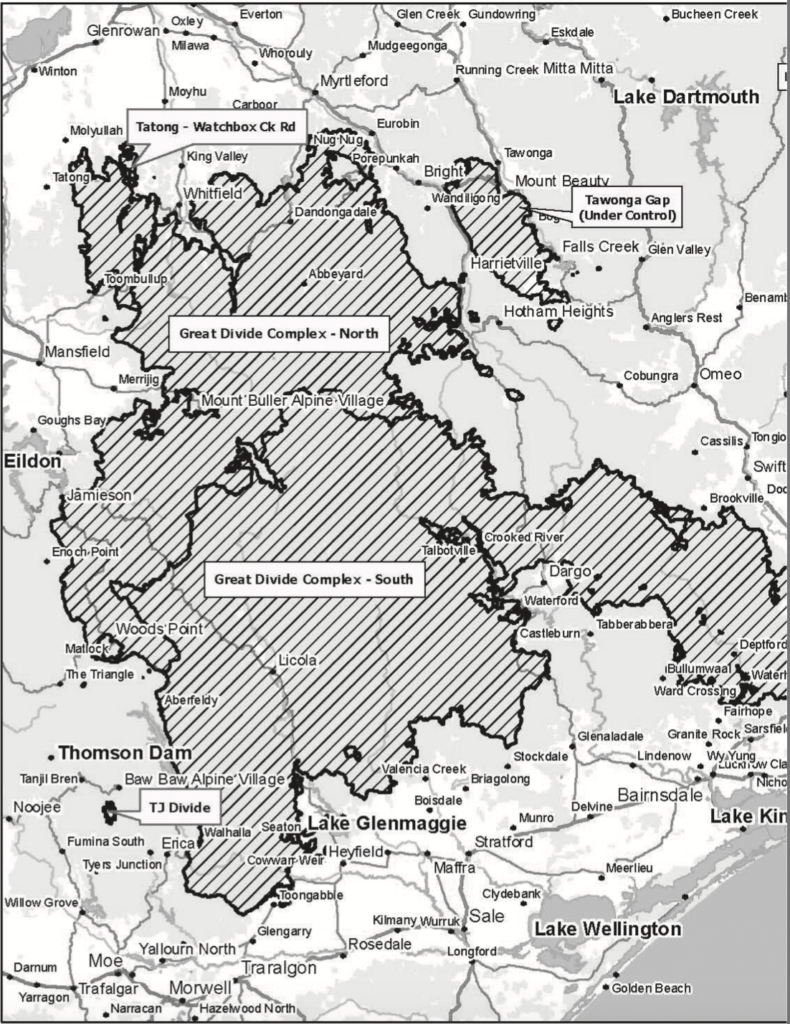
The Eastern Victoria Great Divide fires of 2006-07 were the longest-running bushfires in Victoria’s history. Many of these fires merged to become the Great Divide Complex. The Great Divide North and Tawonga Gap fires covered the broader Ovens valley area and burnt through Mt Buffalo once again and forests in the Buckland Valley near Harrietville.
The 2009 Black Saturday fires were one of the worst in Victoria’s history regarding assets affected. They are well-known as they burnt out populated rural communities. On that day a fire occurred on a section of the Dargo High Plains that previously burnt in 2003.
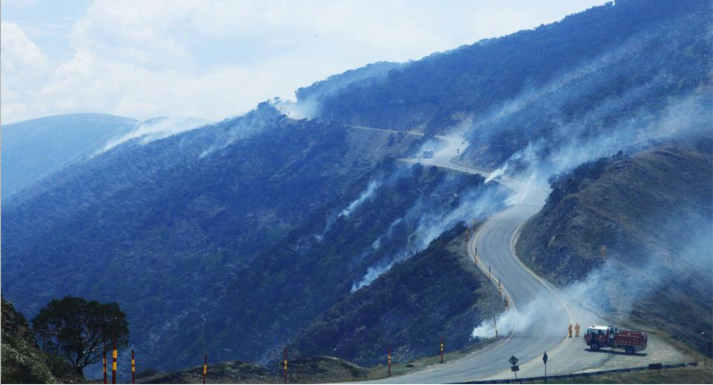
Victoria experienced another significant fire season in 2012-13. Between December and mid-March, more than 190,000 hectares burnt, and five people died, including two firefighters at the Harrietville fire in the Buckland Valley.[5] Lightning on the afternoon of 21 January 2013 started the Harrietville fire near Mt Feathertop, in steep, rugged terrain with limited access. The fire was attacked by ground crews and a bulldozer, as well as aerial water bombing. It was contained within five hectares, even though most of the containment line was a narrow hand-trail. Unfortunately, stronger winds the following morning allowed the fire to escape the containment lines, and attempts to establish new ones failed. There was also spotting several hundred metres ahead, and firefighters were withdrawn from the fire line. Until the fire escaped the containment lines, at around 2:40 pm on 22 January, the fire had not been classified as a significant risk. But later that day, it was described as a ‘large, fast moving bushfire travelling in a south-easterly direction’, and the Great Alpine Road was closed between Harrietville and Mt Hotham. Emergency services evacuated 37 hikers from the Razorback-Mt Feathertop walking trails via helicopter on 23 January.[6] By 8 February, windy conditions had caused the fire to grow to 14,000 hectares and threaten the village at Mt Hotham. Backburning operations commenced on 10 February along the Great Alpine Road’s southern edge between Hotham and Dinner Plain. The fire ran for 55 days and burned 37,000 hectares, including alpine ash forest areas burnt in 2003 and 2007. The local community was critical of the initial response, believing that insufficient resources were deployed during the fire’s initial stages, and it should have been extinguished within the first 24 hours. An inquiry by the Emergency Services Commissioner into the first 72 hours of the Harrietville fire found that ‘there was no information to support the view that an increased weight of attack…would have altered the outcome of the fire’. This view was not supported by the then Fire Services Commissioner, Craig Lapsley. He publicly acknowledged that opportunities were lost in attempts to contain and control the fire in its early stages.[7]
In late 2019, sensitive snow gum (E. pauciflora, ssp pauciflora) communities south of Dinner Plain that burnt in 2003 and 2013, burnt yet again. In early 2020 a large area of the regenerating alpine ash (Eucalyptus delegatensis ssp delegatensis) country in Buffalo National Park was incinerated.
The impacts of the fires
There are ecological consequences of fires such as these burning so frequently in tall mountain forests. There is a real risk that at least 6,000 hectares could convert to shrublands in the absence of viable eucalypt seed. This problem highlights the paradox of fire in the landscape. Mainstream media see fires as a devastating force in the landscape. Foresters see fire as a necessity, and its presence is required to maintain ecological processes and the well-being of tall mountain forests. When our forests are managed through benign neglect, fires which we don’t want or need are allowed to take over the landscape and threaten our forests’ viability. Three devastating fires within ten years threaten the ecological integrity of the alpine ash forests in the victorian high country. There is genuine concern for the survival of alpine ash forests in the Buckland Valley. A particular area that had not burnt since 1939 was burnt in 2003, 2007 and 2013. Around 6,000 hectares of the alpine ash burnt in 2013 were saplings regenerating from the 2003 fires and were not at seed-bearing maturity. We are witnessing ecological shifts in national parks, the very tenure that is relied on to safeguard forests from these threats.
The burnt-out landscape seen today is best summed up in the following words:
“The steamy, mist shrouded forests once attracted condensation and rain. The former micro-climate no longer exists. The barren, lunar landscape these days has created a rain shadow. Without a return to proven fire management, it will never recover its pristine glory.”[8]
With these persistent hot and devastating fires, the fuel profile changes are not good for the forest as it adds considerably to the bushfire threat in the longer term. A severe fire that crowns through a forest removes all the fine fuels, kills trees and damages the surviving ones. Within a year, these dead and damaged trees drop coarse and large fuels. Two years after the fire, the net gain in flammable material is more than 30 tonnes per hectare. After eight years, the net gain increases rapidly as coarse fuels fall from self-pruning coppice and regeneration. The dead trees eventually fall over, adding to the total fuel load. They also severely limit any fire-line construction, particularly with large machines.[9]
Is climate change responsible?
A lot has been written about the causes of these fires. Governments, academia, and non-government organisations have solely blamed climate change for creating conditions that are ‘unprecedented’. For example, climate scientists from the University of East Anglia reviewed research on global climate change. They claimed human-induced climate change promoted the conditions on which wildfires depend, increasing their likelihood.[10] Jason Funk, a senior climate scientist with the University of California, believes there is very well documented scientific evidence that climate change has been increasing the length of fire seasons, the size of the area burnt each year, and the number of wildfires. Nerilie Abram, Associate Professor at the Research School of Earth Sciences, Australian National University, claims the catastrophic fires of last season are primarily the result of rising temperatures.
It was also widely reported that the drought and firestorms of 2019-20 were the consequence of CO2-driven anomalously high air temperature. However, very high temperatures were reliably recorded during earlier droughts. During the Millennium drought of south-eastern regions from 1996 to 2010, Melbourne’s highest temperature was 46.4OC in February 2009. But much earlier, there have been records of similar high temperatures. On Black Thursday 1851, Melbourne recorded 117OF (47.2OC); and Black Friday of 1939, the same place recorded 45.6OC. The weather during the summer of 2019-20 was not unprecedented. Even by climate scientists, it is widely acknowledged that droughts are not increasing, and there is no drying trend in one hundred years of data.
Dr Karl Braganza, from the Bureau of Meteorology (BOM), provided evidence to the 2019-20 Natural Disaster Royal Commission.[11] He used graphs from the 1950s to show trends that claimed worsening fire seasons, hotter droughts, and more extreme heatwaves in spring. He also introduced data using the McArthur Forest Fire Danger Index (FFDI) to support his assertion of hotter and drier weather.[12] The purpose of the presentation was to prove that a human-influenced changing climate has increased the number of high FFDI days. The problem is that the FFDI, despite its name, is a burning index, not a fire danger index. It describes the expected behaviour of a fire burning in standard forest fuel. Dr Braganza used FFDI across Australia in many fuel types that are not a forest.[13] The analysis also failed to recognise changes in the measurement of specific indices over time and how that can impact the calculation of FFDI. Automatic weather stations were introduced in the 1990s. They provide data much more frequently than manual stations. For instance, the wind speed for the FFDI is a mean speed measured over 20 minutes. Today, there is greater availability of wind speed measurements from automatic weather stations at intervals as short as every minute. Calculations of FFDI have used these more frequent values, or even in some cases, wind gust speed. It has resulted in very elevated FFDI readings. Also, there is little attempt in the analysis to relate the rate of spread in different fuels to the difficulty of suppressing a fire. Therefore, the FFDI used across the whole of Australia is not representative of particular areas. Dr Braganza’s presentation simply shows trends that are largely the result of how data used to calculate the FFDI is more a function of the measurement system than actual weather conditions.
To address some of the concerns and uninformed commentary about fires seasons getting longer and wildfires becoming more common and larger, researchers in New Zealand[14] assessed past and present fire danger levels to determine whether climate has impacted the fuel availability for fires over the past four to five decades. Their results show a downward trend in fire danger levels across New Zealand for the past 20 years compared to measurements before 2000.[15]
One only has to look closely at Australia’s geography to understand the physical and climatic conditions that play a role in creating weather that can carry severe fires after ignition. The Australian continent has very flat terrain without significant mountain ranges and no major gulfs to allow marine weather to penetrate inland. Wind systems drive the rainfall patterns over the surrounding oceans. The strength of the south-east trade winds across the Pacific Ocean’s breadth, and the moisture they transport, are critical for rainfall in Queensland. Periodically, the trade winds fail during El Niño events, and rain becomes intermittent, leading to a decade-long dry period, especially in the continent’s eastern part. In New South Wales and Victoria, rainfall variability is also influenced by the dynamics of the Antarctic Ocean, with blocking highs developing over the ocean. In Western Australia, the weather patterns over the Indian Ocean are essential for carrying moisture to the continent. Australia’s flora and fauna have evolved with ‘boom bust’ conditions. Previous fire events reflect these conditions.
Identifying the Indian Ocean Dipole (IOD) phenomena has helped us understand Australia’s weather patterns much better than climate models. Recent scientific work shows that the IOD is a significant contributor to the droughts and flooding rains in Australia, not the least because our weather comes from the west. A strong positive IOD has preceded all our major fire seasons except 2009.[16]
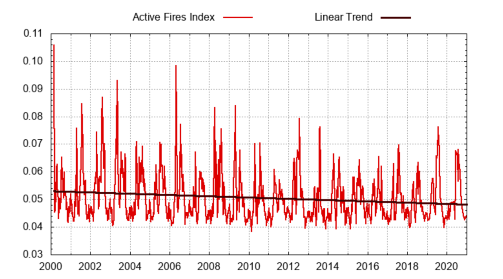
Despite changing climatic conditions across the globe, the truth is that fires have not been increasing. The National Aeronautics and Space Administration (NASA) has collected daily data on active fires since 2000. An analysis of their data shows a decline in global fires this century.[17]
The reality is that it doesn’t matter if Australia’s average annual summer temperature is one degree warmer. Or that drought is a day or month longer. Or whether climate fluctuations are driven by humans or nature. Or whether Australia is doing enough to reduce fossil fuel use. A changing climate does not cause alpine fires or prevent the reduction in forest fuels that made the fires so destructive. These are human-related. Humans start more than 70 per cent of fires. And it is decisions by bureaucrats that are hindering efforts to reduce fuel loads on public land across Australia, more so in Victoria and New South Wales.
Using the best available satellite data, Zoe Phin has produced a map showing the change in vegetation on the Australian continent between 2001 and 2019 – see land-change-in-Australia.
Rather than showing a reduction of forest area due to wholesale clearing, the data shows an increase in forest cover at the grasslands’ expense.[18] What is not recognised in this analysis is the thickening of the understorey beneath these forest areas, which contributes significantly to fuel levels and fire behaviour patterns during severe bushfire weather. Left unmanaged, they contribute to the increased intensity of wildfires during severe fire weather days.
Implications for land managers
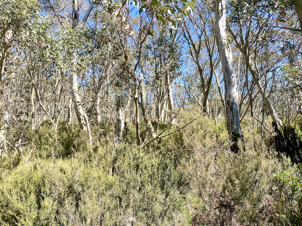
Professional land managers believe the reasons for so many large and regular fire disasters are less about the climate and more about poor policy decisions affecting public land management. Central among these has been the decision to focus on an emergency response to fires rather than mitigating fires by managing forest fuels before fire seasons start. Another factor has been the indifference to prescribed burning. For example, the Gippsland Fire Protection Plan, operational in the lead-up to the 2003 fires, did not include alpine and sub-alpine vegetation communities for prescribed burning. It was based on the belief that fuel hazard levels were generally high or less.[19] This classification ignored the explosion of shrub species underneath the snow gum woodlands that easily burnt in the recent fires. These dense stand persist in areas I saw such as Mt Hotham, Dinner Plain and Mt Buffalo.[20]
I am not the only bushwalker to observe the explosion of shrub growth:
“In my time as a bushwalker, I have seen many trackless, but fairly easy routes used by walkers become overgrown by scrub after cattle have been withdrawn. In one case this turned a route described in a guidebook as lasting one day, into a difficult three-day scrub bash. Apart from making bushwalking less pleasant, the growth of this scrub after the withdrawal of grazing also seems to have led to the area being especially badly burnt in the 2003 fires”.[21]
The original Land Conservation Council (LCC) process in Victoria was designed to assess land use allocation on public lands. In 1983, they recommended the creation of over 1, 5000,000 hectares of new national parks and conservation reserves, including the Snowy River and Alpine National Parks. The Regional Forest Agreement in the mid-1990s created a further 174,000 hectares of new parks and conservation reserves in north-east Victoria. On top of that, 760,000 hectares of State forest ‘Special Protection Zones’ plus management reserves means that there are around 5.7 million hectares of forested preserved land across the state. A further one million hectares of unusable State forest and other forested Crown land effectively act as preservation reserves. Therefore 95 per cent of Victoria’s public forests are part of protected areas. Concomitant with this dramatic increase in reserves over the past 50 years, we have seen an increase in the incidence of massive and damaging bushfires that shows little sign of abating. The regularity of these catastrophic bushfires, which inflict massive ecosystem damage over a few days in summer, clearly highlights the inadequacy of the Victorian Government’s current fire management system.
Under the stewardship of traditional owners over millennia, the native forests in north-east Victoria are adapted to periodic lower intensity fires. European settlement patterns disrupted this balance. However, some form of fuel management persisted. One factor that has been overlooked in the alpine landscape has been the gradual reduction of traditional management by mountain cattlemen from the 1830s. No longer are these areas summer grazed, and mosaic burnt to keep fuel levels low. Cattle grazing has received most of the blame for impacts on the flora of the high plains. However, the effects of the rabbit have been ignored. Based on his first-hand experience over many decades, mountain cattleman and naturalist Keith Rogers,[22] blamed rabbits and the unfortunate practice of carrying out extreme summer burning to promote ‘sweeter cattle feed’ out of the valleys as the cause of a lot of damage to the high country. Sweet herbs and native grasses were eliminated in many parts of the Snowy and Suggan Buggan Valleys. On the tablelands, only coarse grasses were unaffected, reducing the quality of the pastures. Burning in the steeper country was hotter and more destructive and often led to accelerated erosion of loose granitic soils. Rabbits quickly ate any sprouting young grass. The resulting bare areas provided a seedbed for the invasive shrubs such as dogwood (Cassinia spp) and burgan (Leptospermum phylicoides), particularly in the forests and woodlands, replacing the open understorey of native grasses. Fortunately, myxomatosis arrested the decline by rabbits, and summer burning ceased. By the late 1970s, Keith witnessed a return of the pastures and firmly believed that cattle had been wrongly blamed for impacts, particularly moss beds and puddling creeks and overgrazing.[23]
So-called peer review studies claimed that cattle grazing had little effect on reducing fuels. These studies have argued that cattle have not reduced the cover of tall shrubs. Academics even claim that alpine vegetation is resilient to large fires and there is ‘no apparent conservation imperative to mitigate the extent or severity of large fires’. However, Harm van Rees’ work in the early 1980s analysed the diet of cattle on the Bogong High Plains. Van Rees found cattle mainly ate snowgrass in the early summer months and changed to shrubs (alpine star-bush and alpine grevillea) later in summer, followed by a high proportion of forbs (mainly the leaves of the silver snow daisy – Celmisia tomentella) at the end of the grazing season. The large component of shrubs in the diet showed that cattle did play a role in controlling the rate of shrub growth on the high plains.[24]
The singular focus of academic research to lay the blame squarely on highland cattle grazing for environmental issues fails to recognise the impacts of past practices and the effects of rabbits. They also fail to realise that the introduction of benign neglect management has allowed the build-up of fuel and the consequent demise of healthy ecosystems in various seral stages in north-east Victoria. I recently read a document studying the fire response on alpine plant species after the 1998 Caledonian River fire. The report stated that severe and extensive fires in alpine vegetation only occurs once or twice in a century.[25] The intense fires of the twenty-first century clearly show that there is a conservation imperative to limit the severity of large and damaging fires in summer. By ignoring history, academics and present managers repeat past destructive practices that harm Victoria’s high-country environment. In simple terms, managers need to address the problem of shrub invasion which dramatically increases fuel levels. Research needs to shift its attention to studying and reporting on the impacts of government policy changes that favour permanent reserves and the subsequent adverse effects on the alps’ ecology so that government can introduce appropriate management.
Forestry management cannot escape criticism in these areas. Before 1939, forestry was beset by inadequate resourcing. And the foresters, most of whom had European training, believed fires could be eliminated from Victorian state forests. State forests along the Great Dividing Range from Melbourne to the New South Wales border had a much different fire regime to the more isolated high country on Crown land burnt regularly by graziers. Three severe fires in quick succession in 1926, 1932 and 1939 heavily impacted ash forests’ ability to regenerate. For example, on the Toorongo Plateau in the Central Highlands, the ash forests failed to regenerate after these successive high-intensity fires because regenerating trees were not old enough to produce seed from the canopy. Renowned botanist J. H. Willis described the scene he witnessed after he visited the area in 1944:
“…what had been a virgin forest, glorious beech groves, or mossy alpine gardens of surpassing beauty, were transformed in a matter of minutes into a hellish inferno, then left a hideous dreary waste that can never hope to recapture the pristine charm”.[26]
Several reforestation schemes were trialled at Toorongo Plateau but proved to be difficult. Large areas had become grassland until a concerted reforestation program in the late 1980s has successfully turned these areas into high-quality stands of alpine ash. This dilemma is not dissimilar to what the ash forests in the Victorian alps face today.
To their credit, and because of the 1939 Royal Commission, foresters eventually introduced a systematic program of broad-scale landscape burning to manage fuel levels after WWII. Unfortunately, the progressive change in land use of public land from actively managed state forests to national parks left to benign neglect, which started in the late 1970s, has gradually dismantled the forester’s fire management regime.
While Victorians benefitted from the reforms brought in after the 1939 and 1983 bushfires, they are yet to benefit from the 2009 Victorian Bushfires Royal Commission’s many key recommendations some twelve years later. A critical analysis of forest fire management governance and practice in Victoria was written by two experienced fire managers. They highlighted the significantly more costly and less effective way of managing bushfire in Victoria under the ‘top down’ command and control emergency management system; a failure to ensure an adequate state of preparedness commensurate with the known risk; and an increasing failure to attack and quickly bring bushfires under control aggressively.[27]
Former CSIRO bushfire specialist David Packham said Victoria’s ‘failed fire management policy’ was an increasing threat to human life, water supplies, property and the forest environment in his submission to the state’s Inspector-General for Emergency Management. He argued that unless the annual fuel reduction burning target of five per cent ‘is doubled or preferably tripled, a massive bushfire disaster will occur. The forest and alpine environment will decay and be damaged, possibly beyond repair and homes and people [will be] incinerated.’[28] Since that prescient warning, the alpine country has seen large fires in 2016 and 2020 (after the 2003, 2007 and 2013 fires).
The 2013 fires were fuelled by a dense cover of flammable shrubs and regenerating eucalypts that profusely germinated after the 2003 and 2007 fires. Neither frequent destructive fires nor the absence of fire is desirable. On a broad scale, the continued survival of the high-country ash forests and woodlands relies on the active management of deliberate low-intensity fire across the landscape.
In November 2015, the Victorian government decided to do away with one of the 2009 Inquiry’s recommendations to triple the previous levels of prescribed burning to a minimum of five per cent of public land (390,000 ha) per year in favour of a state-wide target to maintain bushfire risk at or below 70 per cent. The Department of Environment, Land, Water and Planning (DELWP) engaged a secret expert group. According to DELWP, these unknown experts ‘through years of research and modelling…have told us that 70 per cent risk is the right level for our state-wide landscape’.[29] The independent group Forest Fire Victoria Inc[30] believes this new policy does not contain any meaningful, verifiable parameters. The failure to achieve planned burning targets is not surprising, given the lack of significant organisational and cultural reform to the agency responsible for managing public land in Victoria. The 2009 Victorian Bushfires Royal Commission implementation monitor (BRCIM) reported in its annual reports in 2013 and 2014:
“Although the amount of planned burning being conducted is higher than for many years, the BRCIM is not convinced that the proposed annual rolling target of 5% minimum of the public land (390,000ha) is achievable, affordable or sustained.”[31]
Since the mid-1990s, the rolling 10-year average annual fuel reduction areas has varied from 80,000 to 150,000 hectares, which is 1-2 per cent of the total public forest estate. Victoria has a challenging environment in which to conduct broad-scale landscape burning, and it repeatedly fails to provide resources and programs to meet that challenge. In 2006, attempts to cover-up the actual figures relating to fuel reduction burns on public land were exposed. The Department of Sustainability and Environment (DSE) had only burnt 43,000 hectares in 2006-07, falling well short of the targeted 130,000 hectares. However, DSE’s website falsely claimed 110,000 hectares were burnt. When they were exposed, the government tried to cover it up. Less than six months later, uncontrollable bushfires ravaged over 1.2 million hectares of public land. This example glaringly showed how public land management was seriously inadequate and how the government had failed in their duty of care to the public.
Equally important is that the government has now abrogated itself and its agencies from being held accountable to achieve defined targets. How can the public be confident that the government can keep them safer from the threat of bushfire emanating from the millions of hectares of public land under its control? The primary aim is no longer to minimise damage to lives and property. There is a much greater emphasis and unlimited money spent on aircraft for fire suppression but very little on minimising the effects of wildfire. The former generates more publicity, is more glamorous, and is convenient to emergency-trained bureaucrats who find the task of preventing wildfires too mundane and difficult.
Bushfire management has morphed into an industry that relies on mega-fires. The value of aerial water bombing is magnified when footage is shown of planes protecting houses on TV screens to portray a sense of success in suppressing a threatening fire at the right moment. In reality, aircraft effectiveness is limited when fires are at high intensity due to high fuel loads and lousy weather. They may save the odd house, but they are ineffective in controlling most forest fires once they grow larger than ten hectares. Aircraft can play a vital role in fire management, but they are not a substitute for ground crews. There is a tendency to use aircraft in inappropriate conditions, drastically inflating the costs of fighting fires. There is no available data that assesses the benefit-cost ratio for these operations. And the massive expenditure on aircraft reduces budgetary resources to carry out off-season activities such as fuel reduction and maintaining forest access that is integral to quickly containing wildfires while they are small. Curiously reports of trials using giant aircraft in south-eastern Australia have generally not been made public.
What needs to be done?
How can the management of the vast Victorian high country get so bad? Is it because public land control is too closely entwined to political ends rather than care of the environment as a primary concern? Everything is biased toward city-centric politicians, greenies and academics. Is it any wonder that today’s forest management problems result from policies promulgated by people who do not understand and don’t know how to manage Australia’s forests?
The tragedy is that these people have no accountability for the continued failed outcomes of their policies. Take, for example, this ambiguous statement from the Alpine and Greater Gippsland Strategic Bushfire Management Plan:
- continue to provide an integrated response to bushfires with CFA and other emergency managers
- share bushfire risk assessment data and information with other fire agencies and land managers (such as PV, CFA, VicForests and private plantation owners) to support bushfire response
- continue to identify and validate our landscape’s priority assets for protection.
What does this mean? Are they committed to a fast, direct initial attack on all fires to put the fire out? It appears not when there is a decline in road and fire trail maintenance which delays a fire crew’s ability to reach a fire. What about the strategic location of standby crews who are employed full time and fully trained, rather than the current reliance on part-time and less experienced firefighters?
The past 20 years has shown that policies covering the role of fire in environmental protection need to be comprehensively revised. The artificial and unachievable aim of excluding fire or a minimal-fire approach through non-interference is unviable. Current land management practices need to change. An adequate fire management system that prioritises fire prevention and all it entails is required rather than the failed emergency fire response system run by city-based bureaucrats. What’s worse is they are never held to account for the charred landscape that has been created from repeated devastating fires we have witnessed this century, particularly in the forested alpine areas of Victoria.
I close with these words from an ex-chief fire officer in Victoria:
“As a society, we have become disconnected from an essential truth; fire is the very essence of conservation in eucalypt forests. As a consequence, massive and continuing environmental disruption from uncontrolled high intensity bushfire has become today’s enduring reality.”[32]
[1] Treasure, D. (2007) Impressions of the fire at Castleburn Voices of the Mountains 30:9-10
[2] The only other major fire was at Mount Buffalo and surrounding areas in 1984 which threatened the small town of Wandiligong. According to forest historian, this was the first major bushfire test for the newly formed Department of Conservation Forest and Lands (CFL).
[3] The fire problem this century is not confined to the Alps. In December 2002 over 180,000 hectares burnt in the north-west of the state at Big Desert Wilderness Park and Wyperfield National Park; in autumn 2005, Wilsons Promontory National Park was burnt; in January 2006 almost all of the Grampians and the Moondarra Park were burnt; and the 2009 Black Saturday fires were the worst in Australia’s history killing 173 people. Almost 80 communities were directly affected, and entire towns were left unrecognisable. The fires burnt through 70 national parks and reserves.
[4] Incoll, R. (2007) Disconnection: a social view of fire management in the mountains. Voice of the Mountains 30:20-25. Rod Incoll worked as a forester in Victoria from 1960-84. He managed areas of alpine forests from 1973-76. He was Chief Fire Officer for several identities of the Department from 1990-1996.
[5] This fire was named ‘the Harrietville fire’ when in fact the fire originated near Mt Feathertop and travelled around Harrietville. The name has contributed to a misleading impression that Harrietville was damaged by fire when in fact the township was not burnt or threatened bv the fire.
[6] The fire was being monitored and no immediate direct fire-fighting efforts were made to contain the fire. By the 24 January, the fire was reported as still moving rapidly and ‘threatening Hotham Heights and Harrietville anytime in the next 24 hours’. After a week of relatively benign weather, the fire was again threatening surrounding towns. Backburning operations started on 3 February south of Harrietville between Old Coach Road and East Ovens River. Over three days from 9 February fire activity heightened considerably with Hotham village at direct risk. Back burning was carried out during this time to save Hotham village and on 13 February to save Dinner Plains. The fire had split into with the southern extent established in the Dargo River valley and increasing in size significantly.
[7] A detailed analysis of the initial response to the fire is presented in a report by the Emergency Services Commissioner at https://librarynswrfs.intersearch.com.au Lapsley’s comments can be seen at https://mobile.abc.net.au/news/2013-06-06/opportunities-missed-fighting-harrietville-fire/4736486?pfmredir=sm&pfm=sm
[8] Christine Finlay, the only Australian to be awarded a doctorate in bushfire management. She drew on her PhD thesis to write a book “Whistleblower”
[9] Forest Fire Victoria Inc (2020) Submission to Inspector-General for Emergency Management Inquiry into the 2019-20 Victorian fire season
[10] https://www.sciencedaily.com/releases/2020/01/200114074046.htm
[11] https://naturaldisaster.royalcommission.gov.au/system/files/exhibit/BOM.502.001.0001_0.pdf
[12] Alan McArthur was a forester and was the first full-time fire control officer of the Snowy Mountains area in 1951. This began his passionate research into the behaviour and control of forest and grassland fires. This led him to the Commonwealth Forestry and Timber Bureau in Canberra as a researcher, and later principal research officer at CSIRO. For more than 25 years he meticulously studied the behaviour of fires devising systems for rating the danger of fires under different weather, topographical and forest fuel conditions. He also developed guidelines for controlled burning which were critical in the development of this practice across the landscape in Australia which contained disastrous fires.
[13] A new fire danger rating system is being developed which aims to focus on the rate of spread of a fire in specific fuel types relevant for an area.
[14] These researchers are well-known and respected forestry, remote sensing and fire and forest specialists in New Zealand.
[15] Dudfield, M., Pearce, H. G. and Cameron, G. (2021) The impact of recent climate on fire danger levels in New Zealand. New Zealand Journal of Forestry 65(4):12-18
[16] Cai, W., Cowan, T., & Raupach, M. (2009). Positive Indian Ocean dipole events precondition southeast Australia bushfires. Geophysical Research Letters, 36, L19710 https://doi.org/10.1029/2009GL039902
[17] https://phzoe.com/2021/02/17/trend-in-global-fires/
[18] Data source https://lpdaac.usgs.gov/products/mcd12c1v006/
[19] Fuel reduction was planned in vegetation communities that reach a fuel hazard rating of ‘very high’ or ‘extreme’ based on McCarthy, G. J., Tolhurst, K. G. & Chatto, K. (1998) Overall Fuel Hazard Guide. Fire Management Branch. Fire Research Report No. 47. Department of Natural Resources and Environment, Melbourne.
[20] It is a similar story on other areas of the alps. In 2007, renowned Victorian forest ecologist Peter Attiwell inspected Wonnangatta Station river flats and Howitt Plain. He noticed a heath monoculture replacing the grasslands. The area was described as ‘overgrown and rank, lacking in biodiversity with fuel loads that would crucify the snow gums’.
[21] A submission from an experienced Victorian high country bushwalker to the Victorian Government’s Alpine Grazing Taskforce published in Voice of the Mountains (2005) page 46.
[22] Keith Churchill Rogers (1896-1978) was a mountain cattleman and naturalist from Wulgulmerang, overlooking the Snowy River. It is 889 metres sea level and Keith ran cattle in the country for 70 years. He witnessed and recorded the changes to the environment during that time.
[23] Rogers, K. C. (1976) Changes in mountain areas. The Clematis 15; Rogers, K. C. (1980) Across mountain and plain: writings of an East Gippsland field naturalist. Bairnsdale Field Naturalists Club, Bairnsdale
[24] van Rees, H. (1983-84) “Study of cattle on the high plains” Voice of the Mountains Issue No 8; van Rees, H. & Holmes, J. H. G. (1986) The botanical composition of the diet of free-ranging cattle on the Alpine Range in Australia. Journal of Range Management 39:392-95; van Rees, H. (1982) The diet of free-ranging cattle on the Bogong High Plains, Victoria. Australian Rangeland Journal 4:29-33
[25] McCarthy, G. J., Tolhurst, K. G. & Chatto, K. (2003) Determination of sustainable fire regimes in the Victorian Alps using plant vital attributes. Research Report No 54. Fire Management Branch. Department of Sustainability and Environment, Melbourne
[26] Quote from short film ‘The Reforestation of Toorongo Plateau’ https://www.youtube.com/watch?v=BSphlOAZygs
[27] Dexter, B. D. & Hogson, A. (2015) “Fire management on public land – Victoria burns while its bureaucracy fiddles”
[28] https://www.theage.com.au/national/victoria/bushfire-scientist-david-packham-warns-of-huge-blaze-threat-urges-increase-in-fuel-reduction-burns-20150312-14259h.html
[29] “Safer together – A new approach to reducing the risk of bushfire in Victoria.” Published 19th November 2015. See www.delwp.vic.gov.au
[30] Forest Fire Victoria was formed in February 2004 by a group of concerned practitioners and scientists dismayed by the disastrous bushfires in eastern States over the summer of 2002-2003. Members have more than 200 years of combined bushfire experience.
[31] Bushfire Royal Commission Implementation Monitor (2013), (2014) Annual Report
[32] Incoll, R. (2007) Disconnection: a social view of fire management in the mountains. Voice of the Mountains 30:20-25
Robert: I invested a lot of time some 8 years ago trying to understand the fire history in S-E Australia. Since then, the story is unquestionably getting worse year-on-year and the reason is very plain to see – but governments are blind by choice.
The two sources of good information that I would force every bloody politician to read are:
• Bill Gammage’s “The Biggest Estate …”
• Stephen Pyne’s “Burning Bush: A Fire History of Australia”
Your latest blog is just pissing in the wind. NOBODY in authority will read it!
Allan
Robert,
The only broad area forest characteristic that can be managed is fuel, and that can be done only by applied fire. The only fire behaviour characteristic the can be managed is fuel, not temperature, or wind, or weather conditions.
Why is that hard to understand?
Maybe it is more a matter of availability of volunteers (most have day jobs)and emergency services (have to be always available for emergency response) for fuel reduction activities on suitable days. For parks staff, budget and policy are king.
After 40 years of ‘pissing against the wind, I’ve come to the firm belief that there are too many people with vested interests in having huge fires for things to change.
Fire authorities want more aeroplanes and red trucks, academics want research grants, and politicians need urban green votes.
Threaten their empires and they get nasty as I found out. The paranoia generated by the ABC and greens pumping up climate change narrative has been overwhelming.
And the future? More of the same. Get used to it.
Geoff, spot on the money.
As “Chicken Little” said One does what one can!
Pyne’s book is still the definitive work on Fire in the Landscape.
Gammages work should be compulsory reading for those who would champion “traditional burning” as the answer to the ignorance and mismanagement that has bought us to this point.
Thanks Robert, a lot of work here, much appreciated. I agree with your theme, particularly on the need to address the shrub invasion, the use of aircraft, and that the major fires are not just a result of climate change, but on poor forest and fire management.
However, I have a different view to your comments on the use of FFDI to track long term changes. I’m not sure of the basis for FFDI being a burning index. Are you thinking of McArthur’s Leaflet 80? Indeed, the predicted behaviour on the back of the calculator is based on a standard forest type, but the FFDI rating was in fact a description of suppression difficulty. The index (eg. 25 VH) only uses weather parameters. Therefore the annual average, accumulated FFDI, or number of days above 25, etc. is still a good guide for tracking weather severity over time, irrespective of location or forest type, and I know of no better measure of fire weather severity.
The difficulties in changing weather recording gear over time is recognized, and a good discussion of this in given by Chris Lucas. He has compiled long term (40 year) fire weather records using unchanged sites across Australia. I have used his data for Queensland fire weather trends, and the increasing severity is definitely consistent across Queensland.
I do believe, however, that poor burning and fuel condition overwhelms the relatively smaller effect on wildfires as a result of this climate change trend.
Thanks Peter. I think we agree that lack of controlled burning and the build of of fuel loads is a much more important consideration than trying to put the blame on a small change in the climate. I would love to get a hold of the dataset used by Braganza and try and replicate what he presented to the Royal Commission. I reckon I would have a field day in showing the discrepancies. For instance, what weather parameters were used to calculate FFDI since automatic weather stations, compared to what was used prior? Was it done in a way to allow comparison of the data over that time span?
Thank you once again Robert Onfray for this vital research and commentary. The current management decisions about fire mitigation seem illogical to many of us. What is really terrifying is the propensity to use climate change as a catch-all excuse to do nothing.
Hopefully social media can go some way to spreading the word to those who need to know the value of mitigation.
Robert, it has taken me a while to get to this as it got lost in my emails. Agree 100% with what you are saying, as I have seen it first hand over he years.
You may not be aware, but I am a motorcycle adventure rider and frequently explore the Victoria high country. I have travelled on firebreaks and tracks in much of it such as Davies Plain track from Tom Groggin to Omeo, Dargo high plains, Wonnangatta from Dargo to Howqua etc. Also, I have covered a lot of Kosciusko National Park and the E.pauciflora forests. I watched a succession of State Governments lock up well managed production forests where the subsequent neglect has been breathtaking.
Daniel Andrew’s solution to the recent fires is to lock up more native forest. People get what they vote for, so tragic.
Thanks Les. Why is it that only foresters are seeing these devastating changes to our forests through political interference, mismanagement and benign neglect?
Thank you for writing this. It breaks my heart to drive through KNP 4 years on. I was in the park riding looking for injured wildlife when embers were still smouldering. The fire was so intense some areas have still not begun to recover. All those beautiful mountain ash gone. The upper canopy gone, forever changing the understory landscape. It’s hard not to shed tears.